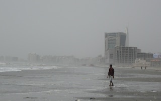
It’s a bright and humid April day in Karachi, on the eve of Ramadan. Muslim Ishaq has just returned to the jetty in Ibrahim Hyderi after the day’s fishing and is tying up his boat. He and his crew set off at 4 am from the small village in Korangi district on southern Pakistan’s coast, where most families depend on fishing.
Inside Ishaq’s boat, his catch amounts to only about 700 kilograms of jellyfish.
Despite having been at sea for eight long hours, Ishaq and his three crew members have not been able to catch anything of substance, and they are frustrated. Worse, they say, this has become the norm.
Rivers, creeks and streams run through Korangi, and the district is prone to flooding. For all the difficulties of life here, the fishers don’t recall settling for jellyfish catches in the past. Over the last 15 years, they have had to.
In the local market, jellyfish sell for around 30 Pakistani rupees per kilogram (about USD 0.15), Ishaq says. In comparison, the cheapest fish sell for at least PKR 500 per kilogram (USD 2.30).
“A few decades back, fishers wouldn’t even think of catching jellyfish,” Ishaq says. “It was the most useless thing. Now we don’t have any other fish available in this part of the sea. But thankfully some demand for jellyfish has sprung up from China.”
In the past 40 years, as Karachi has urbanised rapidly, a huge area of its coast has been developed. In the 1980s, fishers tell The Third Pole, they first noticed that sections of the coastline were being filled in with rocks, pebbles and sand, reclaiming land from the sea to enable the construction of luxury housing, golf resorts and entertainment venues.
“
Developments took place at the expense of floodplains. There’s a significant time lag in water drainage due to the narrowing of these channels, because of which the city gets chocked for at least six to seven hours.
Tariq Alexander Qaiser, founder, TAQ Associates
One of the most affected places is Gizri Creek, a tidal estuary that was once part of a unique wetland ecosystem of mangrove forests around Karachi. In 1986, this water channel covered nearly 14 square kilometres, Ibrahim Zia, senior research officer at Pakistan’s National Institute of Oceanography, tells The Third Pole. Zia calculates this has shrunk to 11 sq km. This means that the equivalent of more than 500 football fields has been taken from the waterway to enable construction work by the Defence Housing Authority (DHA), a real estate developer owned by the Pakistani military.
The neighbourhoods built by the DHA in Karachi are now the most expensive places to live in Pakistan’s largest and most expensive city. The ongoing development frenzy is not only impacting marine ecosystems and local livelihoods, but also contributes to monsoon flooding, puts the city’s residents at risk of sea level rise and is altering the distribution of sediment along this section of the Karachi coastline.
Forty years of land reclamation
In 1980, Muhammad Zia-ul-Haq, who at the time was ruling Pakistan as a military dictator, passed a presidential order to create the DHA across an area sprawling over more than 50 square kilometres in Karachi. The DHA was also given powers of master planning.
The DHA development was not the subject of widespread concern until it started construction work on Phase 8 in 2007. This development, sprawling over a roughly 20 sq km area of land bounded by the Arabian Sea and Gizri Creek, was originally not part of the DHA’s masterplan, as construction was complicated by the coastal marshland terrain.
Phase 8 encompasses multiple projects in varying stages of construction. While roads, a cinema, hospitals, schools, clubs and wedding halls have been built, a large area of land is still lying vacant.
Much of the current construction is taking place on reclaimed land right at the edge of the Arabian Sea and Gizri Creek. This includes two gated high-rise developments, Emaar Pakistan and HMR Waterfront, construction of which started in 2008, as well as the sixth section of the DHA’s Phase 8 – another residential development called E8.
Emaar Pakistan, a subsidiary of the Dubai-based real estate development company Emaar Properties, covers over 30 hectares, while HMR Waterfront (part of conglomerate HMR Group) covers more than 13 hectares.
Using Google Earth, The Third Pole estimates that the total reclaimed area under Phase 8, from Gizri Creek to E8, is around 6.3 sq km.
Development devastates ecology of Gizri Creek
In the 1970s and 80s, fisher Muslim Ishaq says, Gizri Creek was teeming with fish.
Back then, thousands of mangroves grew in the waterways of Korangi district. These trees, with their complex root systems, were nurseries for fish and prawns.
Abdul Majeed Motani, former president of civil society organisation Pakistan Fisherfolk Forum (PFF), fished in these waters for over 50 years. He recalls how the mangroves around what is now the DHA’s Phase 8 “were so dense that even a single man could not pass through them”.
Ishaq, who has been fishing since 1975, says that fishers used to get a good catch just two kilometres from Ibrahim Hyderi village. After two hours of fishing inside the creek they would bring back at least 150 kilograms of prawns.
As more land was reclaimed for development mangroves were cut down, destabilising the delicate ecosystems they sustained. The area of reclaimed land from the creek is now a sea of concrete, wedding halls, clubs and hotels, and the development work shows no sign of stopping.
Now, Ishaq says, even out at sea “we hardly catch eight to 10 kilograms of prawns… if luck favours us”.
Samina Kidwai, director-general at Pakistan’s National Institute of Oceanography (NIO), studied Gizri Creek for her PhD. She says that by 2002 oxygen levels in the waterway were already very low and there was almost no marine life left. She gave two reasons for this: the presence of sewage and loss of mangroves. Ibrahim Zia, the NIO researcher, says that remote sensing data shows a 15 per cent fall in mangrove cover in Gizri Creek between 2000 and 2022 – from about 260 hectares to 220.
Ishaq blames the military housing authorities, the DHA and Cantonment Board Clifton, for “all the mess” in the creeks and the sea, referring to both pollution and ecological disturbance created by land reclamation.
Gentrification excludes fishers from waterways
As massive chunks of coastal land have been reclaimed, rapid gentrification has followed. As part of this process, since the mid-1980s fishers have been denied access to Gizri Creek and several parts of the sea.
Flowing parallel to Gizri Creek is the Korangi Creek. Today, fishers are only allowed to use the Korangi Creek – and even then they are surveilled by the nearby Pakistan Air Force Base and Airmen Golf Course Chalet.
The fishers allege they are humiliated and punished if they go inside Gizri Creek, near Bundal Island or the Emaar Pakistan and HMR Waterfront projects. “If by mistake we end up being near […] the security guards confiscate our boats. They force us into a semi-squatting posture as a punishment,” says one fisher.
The beach for the Emaar Pakistan development, for example, is heavily guarded. This is despite the fact that in 2007 the Sindh High Court restricted the DHA from any kind of development over the beach that restricts public access, stating that the beach is a “public trust”.
Before the formation of the DHA, there was an ancient fishing village called Gizri Village. Abdul Majeed Motani of the Pakistan Fisherfolk Forum (PFF) says that this village used to be home to at least 800 families and thousands of fishers. Now, he says, only 50-60 families and 100 fishers remain. The massive land reclamation and construction around the village led to communities moving or being displaced.
Before the development work ramped up, the fishers of this village had a small jetty. “That is now Marina Club where the rich enjoy, and we are denied entry,” Motani says.
After 1985, when they were barred from Gizri Creek, the fishers protested against the DHA with the support of the PFF. Eventually the DHA agreed to build a jetty near Marina Club where the fishers could keep their boats and continue their livelihoods.
To date, no jetty has been constructed by the DHA and fishers are still barred from Gizri Creek.
Land reclamation exposes Karachi to disasters
To minimise risks to life and damage to property in coastal regions, city planners recommend that developers leave a buffer zone between the urban and natural environments.
The original masterplan for the DHA development from 1975, which The Third Pole has seen, does include a coastal buffer zone, with a roughly 40-metre-wide road, footpath and expanse of beach between properties and the sea. In this plan, the DHA development finishes at Muslim Commercial Area, at the end of Sea View beach.
But Phase 8, which begins at Muslim Commercial Area, has gone far beyond the original plan: the Emaar Pakistan and HMR Waterfront developments are roughly 8 metres at most from the shoreline.
“The biggest problem of the DHA masterplan is that they change it on their whims,” says architect and heritage enthusiast Marvi Mazhar, who has written a report on land reclamation around Karachi’s coastline.
The DHA’s waterfront projects, she says, which are built on soft ground, are a rupture from its original masterplan.
In October 2021, the Sindh High Court issued a stay order to the DHA, barring it further land reclamation. It also restrained the DHA from “granting any reclaimed land to anyone, or creating any third-party interest on these lands or properties built thereon, or changing such lands’ use”. The DHA is additionally barred from using such lands for any commercial purpose, “as well as for holding any functions, including marriage or social functions”.
This means there cannot be any sale of property within the DHA’s Phase VIII development.
However, when The Third Pole visited the Emaar Pakistan gated housing project in April, estate agents were not only selling apartments but also said they can finalise any deal within just two weeks. According to one estate agent, 33 buildings are being built under the project, of which seven have been completed and are partially occupied. The Third Pole also visited several wedding halls, which were continuing to rent out space for weddings and functions.
A simulation exercise organised by the United Nations and officials in Karachi in September 2014 found that a tsunami could “wipe out” the city. With entire housing colonies built on reclaimed land, such an event could be a humanitarian disaster in the city of more than 16 million people.
In light of this, architect Mazhar stresses the need for coastal buffer zones, which she says can save lives and property from cyclones or the huge waves from a tsunami. Only dense mangroves can reduce such impacts, she emphasises.
Currently, more than 80,000 families live in DHA residential developments in Karachi. With Phase 8 due to be the largest phase, tens of thousands of families living in the new neighbourhoods will be at risk if a disaster like a tsunami does happen.
Against such an event, a seawall has been built for the DHA Phase 8’s waterfront projects. Tariq Alexander Qaiser, an architect and environmentalist who has spent decades documenting changes to Karachi’s creeks, says that such constructions cannot withstand a substantial wave. “The wave will hurl the wall up in the air and will break it,” he says.
Another disaster that has been heightened over the past 40 years is flooding. The Korangi and Gizri creeks are the final points of the Indus delta. The Malir River, a distributary of the Indus, flows into the creeks. In the past, Qaiser recalls, during heavy rainfall in Karachi the “floodplain of the Malir River [would become] visibly wide and it used to get filled during massive rainfalls in the city”. Now, due to development and land reclamation, he says the creeks have been narrowed. “Developments took place at the expense of floodplains.”
This shrinking of the floodplain means that water cannot flow through the channels and out to sea, instead entering the city and causing flash floods. At the time of publication, Karachi was still reeling from damage caused by floods triggered by this year’s monsoon rains. In 2020, dozens of people died in the floods, with huge damage to infrastructure.
“There’s a significant time lag in water drainage due to the narrowing of these channels, because of which the city gets chocked for at least six to seven hours,” Qaiser explains.
Waterways are less navigable now
Reclaiming large amounts of land from the sea has also altered the distribution of sediment along the Karachi coastline – a process called longshore drift.
According to Qaiser, in Karachi water currents move from west to east, traditionally depositing at Sea View beach – just before Phase 8 starts. But this pattern has changed, as land reclamation has changed water flows.
“I have observed extra sand deposition on the southwest side of Bundal Island which is some 25 kilometres from Korangi Creek,” says Qaiser.
As the shape of Bundal Island changes, fishers say their boats are getting stuck more often during low tide near Korangi Creek.
Asif Inam, former director-general of the National Institute of Oceanography, tells The Third Pole that environmental impact assessments (EIAs) are not conducted objectively. Because of this, he says it is difficult to ascertain the exact damage caused by land reclamation.
But some immediate impacts can be measured. To ensure that container ships can move through Phitti Creek, east of Gizri Creek, dredging now has to be undertaken by the Port Qasim Authority (PQA). This work comes with a financial cost, Qaiser points out.
Shahid Hafeez, PQA’s director of channel dredging, tells The Third Pole that 5 million cubic metres of sand, mud, clay and slit is dredged every year from Phitti Creek. He was unable to comment on if land reclamation had changed the distribution of sediment, adding that hydrological experts need to gather data and carry out huge studies, which the PQA does not have the budget for.
Legal challenge against the DHA’s land reclamation
In recent years, momentum has been building as legal action mounts against land reclamation in Karachi.
In its October 2021 order against the DHA’s land reclamations, the Sindh High Court referred to reports that the housing authority “had occupied 117 acres of land in Phase 8 illegally and it had reclaimed land over 300 acres”.
Last year, six DHA residents filed a petition in the SHC against the housing authority for cutting mangroves and reclaiming land. Their petition linked severe flooding in 2020 within DHA developments to illegal land reclamation and the narrowing of the area’s water channels.
According to Muhammad Wajid, an advocate for the residents, Gizri Creek’s reclaimed land and all real estate projects being constructed on it belong to Port Qasim Authority (PQA, which was established before the DHA). In 2020, former minister for maritime affairs Ali Zaidi tweeted a picture of PQA’s jurisdiction. It showed that all of the DHA’s Phase 8 falls under PQA’s administrative control.
Legally, land belonging to the port can be used for no purpose other than that of the port, says Zubair Abro, an advocate with expertise in environment-related cases. This was established during a previous Supreme Court case against the Karachi Port Trust.
The DHA, Wajid says, therefore has no legal right to lease wedding halls and residential and commercial projects that fall within the PQA’s jurisdiction.
At least five wedding halls have been constructed inside the creek on reclaimed land. The DHA’s original masterplan has no mention of these sprawling venues (one covers more than 2 hectares), and Abro stresses that the DHA has no legal right to lease reclaimed land for commercial purposes.
In the petition to the SHC, Wajid contended that no approvals were given; no process for converting the land was granted permission; the public were given no opportunity to object; and no occupant of the project obtained any permission from the provincial environment watchdog, the Sindh Environmental Protection Agency (SEPA).
SEPA, in a response submitted to the SHC seen by The Third Pole, stated that none of the wedding halls, marquees, clubs or Emaar Pakistan have obtained the agency’s approval.
For now, the residents’ case is pending. Speaking on condition of anonymity, a person with knowledge of the case told The Third Pole that the plaintiffs are planning to file a contempt case against the DHA and Emaar for violating the SHC’s October 2021 order.
As the legal battles rumble on, to this day the DHA’s rampant development and land reclamation continues, and the chance to mitigate a climate change-fuelled humanitarian disaster on the Karachi coast dwindles.
Abdul Majeed Motani, who has fished in these waters for over 50 years, reflects on the decades he has experienced of the DHA’s development. “There’s no future for us in fishing,” he says, adding that his children have opted for different professions.
This story was published with permission from The Third Pole.


