Farmers in Bangladesh’s coastal region say a changing coastline, erratic rainfall, high temperatures and rising sea levels as a result of climate change pose a threat to the livelihoods of millions.
“I sowed lentils in 2022, but I was not able to harvest the crop as incessant rain wreaked havoc on my field during the chaitra [last] month of the Bengali calendar, which is the peak season of lentil cultivation,” says Makhen Rakhine, a 35-year-old Indigenous farmer in the coastal sub-district of Rangabali, part of Patuakhali district in south-central Bangladesh.
Makhen Rakhine hoped to make a good return on the crop she sows on an acre of leased land. But rains during the dry season in March and April 2023 wreaked havoc on her finances. In the past, Patuakhali district did not experience rains during the dry season.
But in recent years, rains are far more frequent, leaving farmers with heavy losses. Not only are they forced to change cropping patterns because of climatic variability, they say cyclones, salinity and tidal surges together deal a heavy blow to production.
A plague of rain and pests
In an interview with The Third Pole, Makhen Rakhine expresses worries about pests, which “are becoming more aggressive nowadays as their attacks damage crops”. Even pesticides have a limited effect, she tells The Third Pole.
Makhen Rakhine says farmers already battling financial hardships due to erratic weather patterns now have to spend more to produce crops due to the need to control pests and use greater amounts of fertiliser.
Salma Begum, a 40-year-old farmer from Rangabali, highlights a similar issue. Salma Begum’s rice and lentil crops planted with a farmers’ cooperative 2022 were damaged by pests and rains.
“
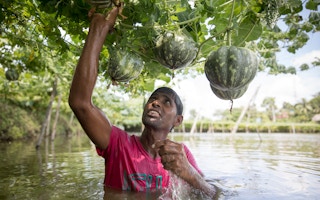
Farmers were forced to sow Aman [the country’s second most sown rice variety] two times this year, [as the] first time, the rice seedlings were damaged due to excessive rainfall. Pulse and watermelon cultivation gets hit hard during the dry season due to the lack of available fresh water.
Mahmud Hasan, chairman, Maududi Union
A 2022 study revealed that extreme temperatures and erratic rainfall resulted in increased pest attacks on rice crops. Furthermore, excessive salinity in the soil has forced farmers to increase the amount of fertiliser they use in paddy fields every year, resulting in the organic matter content in their fields deteriorating.
Mahmud Hasan, chairman of the local council for Maududi Union, a grassroots administrative unit in Rangabali, said the coastal region is now witnessing overall excessive rainfall during the monsoon and excessive drought during the dry season. The rainfall occurring in the dry season damages crops, but does not linger. In the coastal areas, a drought-like situation is created during the dry season due to the lack of fresh water.
“Farmers were forced to sow Aman [the country’s second most sown rice variety] two times this year, [as the] first time, the rice seedlings were damaged due to excessive rainfall. Pulse and watermelon cultivation gets hit hard during the dry season due to the lack of available fresh water,” he says.
During the winter, Hasan says, fresh groundwater levels drop drastically due to low rainfall, and that is why farmers are compelled to spend more money installing artificial water sources to irrigate their fields.
Growing climate disasters
Climate disasters are common in the coastal region of Bangladesh, which is prone to cyclones, floods and tidal surges, and saltwater intrusion. Almost every year, tropical cyclones and floods affect millions of coastal people, leading to loss of lives and massive damage to property.
Hanif Pandit, a fisherman in his 60s from Jahajmara Island in Rangabali, has been fishing in the Bay of Bengal since his childhood. “Cyclones and stormy weather affect the coastal fishermen more as they are,” he tells The Third Pole. “A few days ago, I fell into the sea from our fishing boat after being hit by strong winds. I reached the shore later, via another boat,” he says.
Shahin Bepari, a resident of Char Gangamati in Patuakhali, agrees, and says the wind at sea has become stiffer, and fishing boats are overturned “many times by strong winds, putting the life of fishermen at risk”.
Coastal flooding also severely affects the people living in the country’s 580 km-wide coastal region. A 2022 World Bank study estimated that 8 million people in the country were vulnerable to inundation depths greater than 3 metres due to cyclonic storm surges. It forecast the number will increase to 13.5 million people by 2050.
Rakib Hossain, 40, a fisher from Bhuiyan Kanda in Maudubi Union, says they face annual coastal flooding. Hossain says once floods hit the coastal areas, fishing nets are washed away, putting their sole livelihood in jeopardy.
“Now we cannot catch enough fish from the sea due to adverse weather. Because of cyclones and floods, we have to suspend our fishing for around two months per year. During these periods [the early summer in April/May and the late rainy season in October/November], we suffer a lot trying to cover family expenses,” he said.
Eminent water expert Ainnun Nishat, currently professor emeritus at BRAC University, expresses the fear that super cyclones, which would lead to waves up to 16 feet (nearly 5 metres) high, may hit the Bangladesh coast in the near future due to climate change. “We must get ready to deal with these cyclones.”
Dynamic coastal morphology
Perhaps the greatest challenge for the people living in coastal Bangladesh is the changing coastline itself. The Ganges, Brahmaputra and Meghna (GBM) basin is where rivers flowing from China, Nepal, Bhutan and India meet in Bangladesh, just a hundred kilometres from the coast.
Largely flowing from the young Himalayan mountains, these rivers carry enormous amounts of sediment. A 2021 study by the Center for Environmental and Geographic and Information Services (CEGIS) – a not-for-profit government organisation that reports to the Ministry of Water Resources – estimated that the Ganges, Brahmaputra and Meghna rivers discharge about 1 trillion cubic metres of water and up to 1 billion tonnes of sediment into the Bay of Bengal annually.
“There are many big transboundary rivers, including the Ganges, Brahmaputra and Meghna, which carry a huge volume of silt and deposit this in the Meghna estuary, bringing dynamic changes in coastal morphology,” Maminul Haque Sarker, senior adviser with CEGIS, tells the Third Pole.
Due to this annual flow of sediment, a 2020 research paper based on satellite data calculated there was a 1.15 per cent increase in land area between 1989 and 2018 in the coastal region, a net gain of 591 square kilometres. The coastal area in Bangladesh increased from 28,836 square kilometres (56.06 per cent of the country’s total land area) to 29,427 square kilometres (57.21 per cent) in 2018.
“As Bangladesh receives a huge volume of sediment every year from the Himalayan rivers, its land size is continuously increasing,” Kabir Uddin, co-author of the study, told The Third Pole.
The study suggests it can be used to develop long-term planning for “resettlement, restoration, conservation, and management of the ecosystems and their services across the northern Bay of Bengal”.
As land expands, erosion continues to eat away at the coastline. According to a 2021 coastal erosion vulnerability assessment, about 11 per cent of the coastline has “very high vulnerability” to coastal erosion, while the areas of “high vulnerability” are 24 per cent. During a recent visit to Kuakata in Patuakhali, The Third Pole saw that erosion along 7 kilometres of the area’s coastline had devoured businesses, hotels, reserve forests, homesteads and parks.
A few years ago, the Kuakata National Park was visible near the Kuakata sea beach. Today, however, only two pillars of its entrance remain visible. Two-thirds of it was swallowed by the sea.
An additional 40 hectares of forested land, too, is eroded every year, with a huge number of trees of different species killed and uprooted, a local forest guard with the Patuakhali forest department told The Third Pole. This has put the wildlife and biodiversity of the Gangamati reserved forest, a mangrove forest on the eastern end of the Kuakata beach, in peril.
Mohammad Tanzid, a resident of Char Gangamati in Kuakata, says erosion is taking a heavy toll on their locality. “About 250 metres of land along the Kuakata coastline has gone under seawater in the last five years,” he adds.
Climate impacts – as well as human intervention – are adding to these changes. According to a report by the International Centre for Integrated Mountain Development (ICIMOD) on water, ice, society and ecosystems in the Hindu Kush Himalaya, the supply of water from the Himalayan region will peak in 2050.
The decline in water will mean there will be less sediment as well. At the same time, sea levels are rising. With less sediment and the waters rising, the coastline will be increasingly threatened by the encroaching sea.
Complicated solutions
But in Bangladesh’s National Adaptation Plan, “building 5,816km of coastal embankment in 139 polders [land enclosed by the embankments]” is seen as part of the solution, despite noting that 18 per cent of coastal Bangladesh might be flooded due to sea rise behind existing polders.
In June last year, Environment Minister Md Shahab Uddin, told the Bangladesh parliament that 12-18 per cent of the country was likely to be flooded by sea level rise by the end of the century. Nonetheless, the country seems fixated on short-term solutions that may be adding to the problem by restricting sedimentation.
SM Shahidul Islam, director general of the Bangladesh Water Development Board (BWDB), tells The Third Pole that, with Bangladesh starting a mega project to reclaim land from the sea using silt deposited in the Bay of Bengal, erosion will, in fact, be accelerated.
To address coastal erosion, the BWDB is putting geobags in erosion-prone areas along the coastline, he said, and coastal embankments are being elevated in Patuakhali, Noakhali, Bhola, Barguna and Bagerhat to protect local people and their properties during cyclone, coastal flooding and storm surges.
This story was published with permission from The Third Pole.


