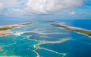
Scientists have completed the first-ever global, high-resolution map of the world’s shallow tropical coral reefs. The map is part of the Allen Coral Atlas, an open-access, user-friendly coral reef monitoring platform, which is now the most comprehensive, consistent and continually updated resource available, according to the developers.
Although coral reefs cover only 1 per cent of the ocean floor, they are home to one-quarter of all marine species. They also provide coastal protection, economic security and dietary protein for hundreds of millions of people.
However, coral reefs are among the world’s most threatened ecosystems. Over just the past five years, marine heat waves have triggered three mass coral bleaching events that have contributed to the loss of 50 per cent of corals in some locations.
With pressure on scientists, reef managers and policymakers to implement conservation measures to safeguard these important ecosystems, access to timely and accurate data on the location and status of reefs is vital.
The new mapping platform, which includes a bleaching detection tool — launched earlier this year and which tracks coral bleaching events in near-real-time — provides an unprecedented overview of the trends and changes in global coral reef health, says the development team, which comprises scientists, technologists and data managers from Arizona State University (ASU), the University of Queensland in Australia, the National Geographic Society, Planet, and Vulcan.
While the completion of the mapping platform is an achievement in itself, the scientists behind the platform say they hope the new resource will spur action to improve coral reef protection.
“The true value of the work will come when coral conservationists are able to better protect coral reefs based on the high-resolution maps and monitoring system,” Greg Asner, managing director of the Allen Coral Atlas and director of ASU’s Center for Global Discovery and Conservation Science, said in a statement. “We must double down and use this tool as we work to save coral reefs from the impacts of our climate crisis and other threats.”
“
There are countries, organisations and government agencies in the world that don’t have a map of their reefs … so these maps will help people by basically giving a baseline to better assess where action is needed.
Chris Roelfsema, principal mapping investigator, Allen Coral Atlas
A global collaboration
The researchers spent three years on the coral reef maps, during which time they analyzed more than 2 million high-resolution satellite images and gathered coral reef data from more than 450 research teams around the world.
Using satellite imagery from US-based imaging company Planet, new and existing habitat data, water depths, and object-based verification, the researchers employed semi-automated machine learning to rapidly classify the broad habitats and underlying geomorphology of shallow coastal marine areas to a depth of between 10 and 15 meters (33 and 49 feet).
The completed map covers 253,000 square kilometers (97,700 square miles) of shallow coral reefs and captures underwater features in unprecedented detail. It reveals the extent of coral reefs and five other benthic components of the seafloor, including sand, rock and seagrass beds, and depicts 12 structural attributes of shallow seas, including reef slopes, crests, flats and lagoons. The satellite imagery also provides a visual representation of abiotic factors, such as wave exposure and turbidity.
Conservation game changer
Traditional marine monitoring and mapping methods using aerial photography and scuba, snorkeling or sonar techniques are time-consuming and often prohibitively expensive. The researchers involved in the initiative say the rapid assessment of reef areas provided through the Allen Coral Atlas is a game changer and is already being used to support conservation projects in more than 30 countries, from Indonesia, the Philippines and Myanmar, to Kenya, Mozambique and Fiji.
In particular, the online mapping resource can provide the foundational data on which proposals for marine protected areas and marine spatial plans can be built. The data are especially useful in previously unmapped regions.
“There are countries, organisations and government agencies in the world that don’t have a map of their reefs … so these maps will help people by basically giving a baseline to better assess where action is needed,” Chris Roelfsema, principal mapping investigator of the Allen Coral Atlas and senior research fellow at the University of Queensland, told Mongabay. “We can better make plans for marine protected areas, or we can extrapolate fish biomass or look at carbon stocks and all those kind of things that up until now were not possible.”
The new platform can also help to identify broader pressures, including pollution and runoff sources and destruction following acute events like cyclones or ship groundings.
Combined with the coral bleaching detection system that was launched as part of the platform earlier this year, the Allen Coral Atlas maps allow scientists and reef managers to see where and to what extent bleaching is likely to be occurring as well as where there is no bleaching. This can help managers relieve such pressures as recreational diving and commercial fishing on reefs that are under stress and identify more resilient reefs with heat-resistant corals that could potentially be used for restoration purposes.
This bleaching surveillance feature spotlights the plight of coral reefs in the face of climate change. With models predicting that 70-90 per cent of the world’s coral reefs will disappear over the next three decades if we do not take action to mitigate the effects of climate change and other anthropogenic pressures, universal access to maps that inform users on the health of coral reefs is an important aspect of the platform.
“We need to protect coral reefs from all fronts,” Roelfsema said. “This needs to start from localised management using marine protected areas and reducing harmful activities and assisting rehabilitation. We are all connected to the ocean and reefs. Climate change is impacting these reefs and we all are impacting climate change.”
Roelfsema says he hopes the Allen Coral Atlas’s capacity to engage people around the world in coral reef science will ultimately help to ensure the ecosystem’s long-term survival. “Once you get people involved, they better understand it and then they learn to take care of it.”
This story was published with permission from Mongabay.com.


