Celebrating the Eid al-Adha holiday should have been one of the most joyous occasions on the Malaysian calendar. However, many villagers living in the kampongs (rural communities) near the town of Baling spent the day in emergency shelters trying to recover from the flood which struck them six days earlier.
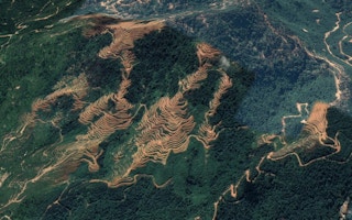
A three-hour downpour starting on the afternoon of 4 July quickly turned into a deluge of rainwater, mud and debris which consumed 12 villages on the foothills of Gunung Inas, a mountain which has been partially deforested and developed into rubber and durian plantations.
The next morning, the bodies of Salmah Mat Akib, 53, and her pregnant daughter-in-law Nurul Anis Hassan, 23, were found in an embrace under a pile of logs. Akib’s son, Khairul Ikhwan Nor Azman, 14, was also found dead nearby. Officials estimate more than 1,000 people have been displaced and 800 homes damaged, 17 of which were completely destroyed. According to the Rubber Industry Smallholders Development Authority (RISDA), 98 hectares of rubber plantations have been damaged as well, jeopardising the livelihoods of 140 local smallholders.
Though longtime residents of nearby Kampong Iboi are no stranger to floods, many say the 4 July incident was of unprecedented proportions.
“In the past, despite two days of downpour, it was nothing like this. The water catchment pond has also overflowed. All the shops here have been washed away by the floodwaters. I think this has been the biggest flood in decades,” villager Tahak Lahamat recounted.
Though nearly one month has passed since the flood occurred, considerable confusion remains over what exactly caused the flood. On 13 July, Kedah First Minister Datuk Seri Muhammad Sanusi urged citizens to refrain from speculation and wait for the government departments to publish their official findings.
“We need to wait for the reports from the Malaysian Mineral and Geoscience Department, Drainage and Irrigation Department and Forestry Department. I am aware that some quarters are pressuring me to say the incident was caused by the Musang King durian plantation [in Gunang Inas]. However, I must wait for the reports. Should their findings prove otherwise, I will be seen as flip-flopping,” he said during the weekly executive council meeting in Wisma Darul Aman on 13 July.
However, during a press conference in Baling on 6 July, Sanusi had already attributed the floods to excessive rainfall accumulating and flowing down from Gunung Inas into the disaster areas, citing the observations he had made while accompanying an aerial survey with the Royal Malaysian Police (RMP). He also dismissed earlier claims stating that the floods were triggered by a burst water reservoir.
Sanusi has not been the only government official backtracking on his statements. On 6 July, Environment and Water Minister Datuk Seri Tuan Ibrahim attributed the floods to continuous excessive rainfall, adding that 40mm of rain was recorded at the Kampung Sedim and Kampung Iboi weather stations, and 64mm had been recorded at the nearby Felda Teloi Kanan weather station. However, on 18 July, he implied that the amount of rainfall was unremarkable, and that contrary to Sanusi’s previous conclusion, a burst reservoir is to blame.
“If we look at the amount of rainfall, it was not more than 40mm. So, our initial studies show that the reservoir built on the plantation area had burst, causing the floods,” Ibrahim said, in response to a supplementary question by Jelutong Member of Parliament R. S. N. Rayer.
Though a full report on the 4 July floods will likely be released later this week, many politicians and activists say the tragedy could have been avoided if Gunung Inas had remained undeveloped.
“
It’s become instinctive to hide information. That’s the current culture, and it’s completely dystopian.
Kiu Jia Yaw, co-chair, Bar Council Environment and Climate Change Committee
In a Facebook post on 12 July, two-time former Kedah First Minister and Jitra politician Datuk Seri Utama Mukhriz Mahathir recounted Gunung Inas’ land use history. He claims that the former Gunung Inas Forest Reserve had been de-gazetted and marked for agricultural use by the outgoing Barisan Nasional administration in 2007. Despite objections from local villagers and politicians like himself, Mahathir further recounted that the Malaysian Islamic Party (PAS) administration, led by Azizan Abdul Razak, allowed Kedah Agro Bhd, a subsidiary of the Kingdom of Kedah, to begin clearing and converting the mountain into a dual-purpose timber latex clone (TLC) rubber tree plantation in 2012.
Though numbers are unclear, some locals say the plantation occupies 12,000 hectares of land. As Kedah Agro Sdn Bhd was unable to manage such a large area, the next administration under Datuk Seri Ahmad Bashah allowed another company, ECK Development Bhd, to convert the area into a durian plantation in 2016. During Mahathir’s second term (2018 - 2020), he claimed his administration limited the amount of durian trees planted, and attempted to supplement reforesting efforts with seven more tree species. Upon realising ECK Development was also unable to complete the project, Mahathir claimed the Sanusi government halted the durian plantation and began replanting work.
Furthermore, Mahathir also questioned whether appropriate environment impact assessments (EIAs) were provided to justify placing TLC or durian plantations on Gunung Inas, further adding that the tragedy on 4 July could have been prevented if the forest reserve had been untouched, or if replanting efforts were completed satisfactorily.
“While replanting trees may cause some soil disturbance, it would not result in soil erosion or flooding. As shown by PAS’ handling of the Ladang Rakyat project in Kelantan, flooding can occur if replanting work is not done properly. The disaster would also not have happened if the forest reserve had not been logged for its high-value trees and approved for development before 2013,” he explained.
During a press conference in Kampong Iboi on 16 July, Mohammad Sobri Ramlee, a campaigner for conservation group Sahabat Alam Sik, pointed out that the plantation was placed in a Rank 1 environmentally sensitive area (ESA), where “no development, agriculture, or logging shall be permitted except for low-impact tourism, research and education”. Furthermore, he also argued that the durian plantation was placed on a 25-degree slope, which is not legally permitted due to high erosion risk.
Apart from the official government investigation, Ramlee and 36 other non-government organisations (NGOs) called for the release of any planning documents related to the 4 July floods, and for a more rigorous Royal Commission Inquiry to be set up. To prevent future disasters, the NGOs also requested that the state government review other forest development projects like those in the Ulu Mada and Teloi Forest Reserves in Sik, Kedah.
To ensure Malaysia fulfils its Sustainable Development Goals, Kiu Jia Yaw, the co-chair of the Bar Council Environment and Climate Change Committee, stated that Malaysia’s political culture needs to change.
“Right now, everything unless otherwise stated is an official secret. The Official Secrets Act makes it a crime for people to disclose [sensitive information], so it’s become instinctive to hide information. That’s the current culture, and it’s completely dystopian,” he said, in an interview with Eco-Business.


