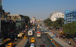

In many ways, Kolkata is a victim of its own success.
Such has been population growth in India’s “first city” since colonial times that where to house people has been a perennial problem. It is now vital for Kolkata’s 15 million residents that planning for future growth takes into account the threat of climate change.
The city has spread so far from its original boundaries and chewed up so much surrounding land that the only way to go now is up. That is, high-rise.
Kolkata’s growth was probably inevitable.
From the 16th century, European traders (starting with the Portuguese, followed by the Danes, Dutch, French and the British) were attracted to the region by trade. They established offices and works to transact with local agents. These settlements developed into towns over the next two centuries.
Colonial Calcutta
The city really took off when the British defeated the nawab of Bengal in 1757 and made Calcutta (as it was then known) their capital, a status it enjoyed up to 1911. The city of Kolkata started with its nucleus in the fort beside the River Hooghly and the port. The port was the hub of mercantile prosperity. It led to the development of transportation with the construction of new waterways and roads.
The first railway line opened in 1854 with the railway station at Howrah. Within 50 years, the whole region, stretching about 60km from north to south (Bansberia to Uluberia in the west bank and Kanchrapara to Budge Budge on the east bank), was dotted with jute, metal processing, engineering and paper factories and railway workshops. These factories attracted people from the neighbouring districts and provinces.
These industrial towns shaped land use in the area. The location of factories was decided by the cheapest means of transport available. Residential segregation followed a new industrial hierarchy, juxtaposed by old indigenous caste-based mohallas (neighbourhoods) and the new wealthy landed gentry.
Calcutta emerged as an administrative and trading town. The port in the western part had its own infrastructure with warehouses along the river. The largest wholesale market was in the northern part of the city while government activities and the Europeans’ homes were confined to the centre. The northern part was native habitation with narrow lanes. The thoroughfares had commercial establishments, recreational establishments, educational and medical institutions.
The area ‘South of Park Street’ started to develop in the late 18th century. It had wider roads and was mainly inhabited by the newly-emerging educated, salaried and professional class. Not only Bengali but others as well. The establishment of the Calcutta Improvement Trust in 1911 led to the expansion of the city to the east and the south and renewal of the central part of the city following Patrick Geddes’s recommendation.
The story of Calcutta is not complete without mentioning its slums. These single-storey tenements were built by a group of intermediaries on the land of local landlords. They were initially home to the large contingents of domestic workers but were later rented to other migrant workers.
Post-colonial city
With Indian independence in 1947 came the partition of India. Bengal was one of the two states (with Punjab) that was split. The region faced a massive influx of refugees from what became East Pakistan (now Bangladesh). The refugees occupied any available empty land in and around the city, especially in its south and east. Most of the vacant mansions of the wealthy class (absentee landlords) were forcefully occupied. This brought the biggest transformation of the city and its suburbs.
The existing urban infrastructure became inadequate. The Calcutta Metropolitan Planning Organisation was formed in 1958 with active technical and financial support of the Ford Foundation. It formally delineated the Calcutta Metropolitan District as the region of influence in Calcutta. The Metropolitan Planning Organisation published a Basic Development Plan (1966-86) for the metropolitan district. It was succeeded by the Calcutta Metropolitan Development Authority.
Meanwhile, the city was suffering from acute shortage of residential space. The rental market was almost frozen with the Rent Control Act. The population started to spread to neighbouring municipalities. The growth rate of some of these towns exceeded 100 percent in the 1970s. Two planned townships of Kalyani and Bidhannagar emerged in the 1960s and the 1970s to relieve pressure on the main city of Kolkata. Kalyani failed to decongest Kolkata mainly because of the commuting distance. Bidhannagar was more successful as it not only attracted a residential population but also a major section of the government offices to its core.
The development authority improved the habitability of the region. With the change of guard in 1977, when a letfist alliance government came to power in the state, the development authority became more democratic in character with wider representation of councillors from various municipalities. The Town and Country Planning Act came into being in 1979. The Calcutta Metropolitan District was changed to Kolkata Metropolitan Area, and became the main instrument to check unplanned development.
Even with such planning and control efforts, there was an immense change in the land-use and land cover of the area because of economic changes. This has led to the emergence of many new “census towns” (defined as settlements with a population of more than 5,000, density more than 1,000 per square kilometre and 75 percent of the male working population engaged in non-agricultural occupations).
A recent study has shown that about 56 percent of the metropolitan area is built-up. Over a period of only five years (2010-15), the built-up area in Kolkata increased by 9.81 per cent at the cost of decline of vegetation (3.48), water bodies (0.04) and agricultural land (6.38).
The easy availability of home loans made it easier for people to purchase apartments. While big real-estate companies eyed greenfield projects on the outskirts of the city and the recycling of industrial land in smaller towns, the smaller ‘promoters’ went for renewing older properties within the cities. The slum lands were protected by the Thika Tenancy Act, but recent changes may lead to dense vertical development very soon. Another noticeable change is the transformation of old residential properties for commercial use — the front of the property is converted to a shop or office while the rear portion continues as a private residence. This adds to the value of the property and helps in its maintenance.
Kolkata and other cities in the Kolkata Metropolitan Area have been transformed into mega service centres. There are also numerous small factories within localities but they are difficult to identify because of a mixed land-use pattern. The demand for homes has increased because of easy and cost-effective access to many facilities. This is reflected in the increase in built-up area at the cost of vacant spaces and wetlands.
Colonial planning aimed to attract more people to Kolkata and adjoining areas. However, post-colonial planning seems more about crisis management in a near-stagnant economy.
As recent cyclones from the Bay of Bengal have underlined, Kolkata is also vulnerable to climate change. The immediate need is for proactive planning and monitoring so the growth of unplanned built-up areas can be controlled. Saving and preserving wetland and vegetation cover has to be a priority. To do that, vertical growth with proper infrastructure focused on compact growth is the only way out.
Mahalaya Chatterjee is a professor at the Department of Economics, Calcutta University, India.
Originally published under Creative Commons by 360info™.


