Fires in Indonesia have razed an area the size of Puerto Rico, following a sharp spike in burning in September.
The fires this year, the worst since 2015, have burned 8,578 square kilometers (3,304 square miles) of land across the country as of the end of September, according to figures from the Ministry of Environment and Forestry. That’s more than double the total at the end of August, of just under 3,287 square kilometers (1,267 square miles).
“There’s a 160 per cent increase [of burned areas] since August,” Raffles B. Pandjaitan, the ministry’s head of fire mitigation, told reporters in Jakarta.
The area burned this year is far smaller than the 26,000 square kilometers (10,000 square miles) burned in 2015, when similar drier-than-usual conditions were exacerbated by an El Niño cycle. But it’s much larger than in the preceding three years, which topped out at 5,106 square kilometers (1,971 square miles) burned in 2018.
“
I expect most smoke-producing 2019 fires burn idle ‘already-deforested-by-previous-burning’ degraded drained peatlands covered by fire-prone scrubs and ferns.
Raffles B. Pandjaitan, head of fire mitigation, Indonesian Ministry of Environment and Forestry
“Indeed, there’s an increase in the number of hotspots in 2019,” Raffles said. “If the hotspots increased [in number], then the size of burned areas must have increased. There’s an increase of nearly 198 per cent compared to 2018. But if we compare that to 2015, then it’s still far below 2015.”
Kalimantan, the Indonesian part of Borneo Island, is the worst-affected region, with 4,281 square kilometers (1,653 square miles) of areas burned, followed by Sumatra with 1,887 square kilometers (729 square miles).
About a quarter of the burned areas, or 2,273 square kilometers (878 square miles), are peatlands, similar to the proportion in recent years. Raffles said 93 per cent of the fires occurred in areas without standing forest. This finding is in line with analyses by the Center for International Forestry (CIFOR) of burned areas for 2013 and 2014 in Sumatra’s Riau province and 1997 and 2015 for Central Kalimantan province. The analysis found that most fires during those periods were in deforested areas, according to CIFOR landscape researcher David Gaveau.
“Based on our previous analysis, I expect most smoke-producing 2019 fires burn idle ‘already-deforested-by-previous-burning’ degraded drained peatlands covered by fire-prone scrubs and ferns,” he told Mongabay. “Those degraded lands used to be forest but never regenerated into forests because of repeated burning, and were never converted to plantations because attempts to establish plantations failed.”
Fires still burning
Raffles said the burning was expected to continue through to the end of the year, with fires still going on in Sumatra’s Jambi province and eastern areas of Java Island.
Hotspots in Jambi province increased by 39 per cent, with fires spreading to Berbak Sembilang National Park. The provincial capital, also called Jambi, has been shrouded in the resulting haze, with air quality levels deteriorating to hazardous levels and forcing the local government to order elementary schools shut.
In East Java, fires were detected on the slopes of seven mountains: Arjuna, Welirang, Kawi, Semeru, Bromo and Ijen. Firefighters have had difficulty extinguishing the fires due to strong winds.
Raffles said the intensity of the fires had declined as rain had started to fall in some regions. “[The number of hotspots in] October is drastically down compared to September,” he said.
There were 3,054 hotspots in October, down from 16,429 in September, according to ministry data.
“And this figure will continue to decline with more frequent rain,” Raffles said. “In Kalimantan and Sumatra, [rains] have started [to fall]. But in eastern parts [of Indonesia], it’s still dry, including in East Java.”
He said he expected the increase in burned areas not to be significant. “We will update the figure, but the increase won’t be as drastic as the one that occurred between August and September,” he said. “I’m sure of it.”
Haze waning
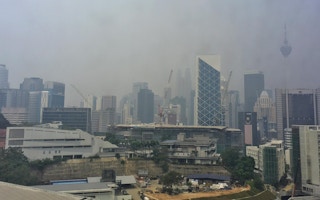
With this year’s dry season approaching its end, the intensity of the haze has also tapered off. Raffles said no haze had been detected outside the country’s borders last month, compared to previous months when the smoke affected Singapore and parts of Malaysia.
“There’s been no more transboundary haze since September,” he said.
The issue of transboundary haze was brought up by delegates of neighboring Southeast Asian countries at a recent regional ministerial meeting on the environment in Cambodia. Raffles, who attended the meeting in Cambodia, said the other delegates and governments were aware of Indonesia’s commitment to tackle the issue.
“At the meeting, I reported that Indonesia had taken efforts to mitigate land and forest fires,” he said. “And the nine other countries greatly appreciated Indonesia’s efforts.”
Cambodian Environment Minister Say Samal reminded the member states of the Association of Southeast Asian Nations (ASEAN) that they needed to work together to tackle transboundary haze if the region wanted to be haze-free by 2020. ASEAN members signed an agreement on transboundary haze pollution in 2002, which went into force in 2003. However, they haven’t come up with any mechanism, either locally or regionally, to implement the accord effectively.
“The vision of haze free ASEAN by 2020 is approaching,” Samal said as quoted by VOA Khmer. “As we move closer to this target date, we need to step up our efforts, and work collectively and progressively to prevent transboundary smoke haze pollution.”
This story was published with permission from Mongabay.com


