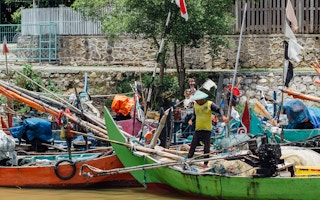
In late July, a high-speed chase stirred the waters northeast of Indonesia’s Natuna Islands, as patrol officers pursued a Vietnamese vessel suspected of illegal fishing.
Having fled when authorities approached it for questioning, the Vietnamese crew tossed a fishing net to purge implicating evidence, burned tires to cloud their sight, and zigzagged across the water to evade capture, according to the Indonesian side’s account of the incident. Indonesian officers ordered the sailors to stop. Instead, they tried to ram into the patrol boat.
A visit, board, search and seizure team fired a warning shot into the air, but the Vietnamese attempted to escape. It was only after the team shot the fishing vessel’s platform that it slowed down and yielded to inspection, which uncovered two tonnes of fish.
The Indonesian Maritime Information Center (IMIC), launched days earlier, on July 22, had helped detect the Vietnamese boat by pooling high-quality surveillance data from several government bodies, according to Demo Putra from the Indonesian Coast Guard (Bakamla), which oversees this initiative.
Bakamla says it hopes this intelligence hub, the first of its kind, will curb illegal, unreported and unregulated (IUU) fishing and other security incidents around Indonesian waters by enhancing and expediting coordination among the many agencies involved in regulating them and by offering a public-facing data-sharing outlet.
“We don’t have a comprehensive picture of the maritime situation because the information is separated depending on the agencies and incident type,” Putra told Mongabay. “We established IMIC to integrate all information in Indonesia and create operational planning based on data from every agency. Planning will be better because the data is more comprehensive, more accurate because it’s analysed by a lot of agencies.”
Despite the ramp-up of regulation and enforcement spearheaded by Susi Pudjiastuti, Indonesia’s fisheries minister from 2014-2019, IUU fishing remains rife in Indonesia, authorities say. Locals disregard designated fishing zones and use ecologically harmful equipment.
Vietnamese, Malaysian, Filipino and Chinese operators routinely exploit Indonesia’s territorial waters, including in the “North Natuna Sea.” This is Jakarta’s name for the waters near the Natuna Islands stretching up to the edge of Indonesia’s exclusive economic zone, and part of which China includes inside its contentious “nine-dash line” that it uses to lay claim to the entire South China Sea.
“Indonesia is attractive to IUU fishing activities because of its rich fisheries resources,” said Reniel Cabral, assistant researcher with the Sustainable Fisheries Group at the University of California, Santa Barbara. “Its people are also victims of human trafficking and forced labour in the fisheries industry.”
IMIC fills the void left by a task force on illegal fishing that was formed in 2015 but dissolved when Susi left office last year. Its disbandment “caused high fragmentation of law enforcement authorities, which weakens control and surveillance efforts to ensure the use of Indonesian marine resources sustainably,” said Muhammad Arifuddin, program manager for Destructive Fishing Watch Indonesia.
IMIC seeks to strengthen interagency communication and cooperation. Besides Bakamla, it involves the Ministry of Marine Affairs and Fisheries (KKP), the Coordinating Ministry of Maritime and Investment Affairs, the Water and Air Police Corps, the Ministry of Transportation’s Directorate General of Sea Transportation, the Ministry of Finance’s Directorate General of Customs and Excise, the National Institute of Aeronautics and Space, and the National Search and Rescue Agency.
The data analysts, maritime security analysts and IT professionals working for IMIC collect and verify daily maritime intelligence from these agencies, the public and some other countries. The governmental data comes from a range of sources, including satellite imagery, aerial surveillance, and ships’ automatic identification systems (AIS), which broadcast their identity, course and speed.
IMIC publishes the updates on its website, categorised by case type. It also visualises occurrences each month and gives pertinent analyses and recommendations for seafarers.
For example, Putra said, when “a lot of Indonesian fishermen are arrested by [foreign officials] in disputed areas, we advise them to make sure they’re within Indonesian waters.”
IMIC releases more in-depth bi-weekly, monthly and longer-term reports, too, disseminating them through fishers’ outreach programs and associations as well as posting them online. People can provide tips and receive information by contacting the IMIC support center.
“By having this information [disseminated] comprehensively and freely, we hope maritime stakeholders’ concern will increase and illegal activities will decrease,” Putra said.
Meanwhile, the government can gain extensive insight into the prevalence, hotspots and trends of maritime threats like IUU fishing by using IMIC, which could promote faster, more effective responses.
“Decision-making will be better because the information is comprehensive,” Putra said. “We can say that because this area has higher IUU fishing, our plan should focus here.”
For instance, the first month’s data revealed that the Arafura Sea, south of Papua, teemed with IUU fishing activity, he said.
Arifuddin said IMIC had made Bakamla the nation’s “pioneer” in pinpointing fishing violations with heat maps.
“With web-GIS technology, the data become interactive and easier for policymakers to determine policies, budgeting and focus locations and to advocate for international relations to countries that become IUUF actors in Indonesia,” he said. “If these things are utilised optimally, then Indonesia’s marine ecosystem will be better managed and have a bright future.”
IMIC’s combining of technologies from across various agencies and ministries could even deter fishers from IUU practices, said Wildan Ghiffary, program officer for Global Fishing Watch, an online mapping platform that tracks ship movements across the world.
“With IMIC and stronger collabouration between institutions such as the KKP and Navy, I expect IUU fishing will decrease, especially in hotspots with foreign vessels,” he said. “Vessels coming to Indonesia to do illegal fishing may decrease because they‘re aware we have stronger surveillance.”
Streamlining knowledge management across isolated parts of government is tough, experts say, so IMIC has a few kinks. For example, Arifuddin said, it doesn’t cite sources or describe its methodology.
“It’s likely the data exchange between ministries wasn’t run smoothly,” he said. “A lot of information on IMIC is most likely from online news and not detailed. The accuracy of the coordinates of events on the map is somewhat questionable. And the recommendation in the monthly report was general, not specific.”
At Bakamla, Putra said, raising awareness of IMIC’s value as an official information channel is a difficult goal, and obtaining data is time-consuming since government bodies’ digital systems aren’t integrated.
“We still have to call or email to get information,” he said. “It’s overwhelming because there’s a lot of work to make sure we collect every piece of data in Indonesia.”
Even so, IMIC seems to be moving in the right direction, Arifuddin said. “I think IMIC will develop step by step.”
Putra called the initiative a “stepping stone.” He said there would be greater synergy down the road, with 12 government departments manning the situation room at Bakamla headquarters in Jakarta.
An upgrade to a synchronized data system free from manual inputs is underway, he said. It should help quicken information gathering and processing, allowing for weekly or daily reports.
Cultivating the trust of fishers and sailors via the support center will be crucial to keep them out of trouble, Putra added.
Cabral stressed the importance of robust monitoring and enforcement to reduce IUU fishing and fisheries-related human rights abuses and protect the marine ecosystems Indonesians depend on for their livelihoods.
“The potential availability of timely information through IMIC could help Indonesia control IUU fishing as well as address human rights violations,” he said. “If successful, this can definitely have a tremendous positive impact on fishers’ welfare, fisheries sustainability and marine biodiversity.”
This story was published with permission from Mongabay.com.