With the help of “eyes in the sky”, Greenpeace Southeast Asia has shot a video that shows some of the origins of the smoke that has enveloped several countries in Southeast Asia for more than a month now.
To continue watching, subscribe to Eco‑Business.
There's something for everyone. We offer a range of subscription plans.
- Access our stories and receive our Insights Weekly newsletter with the free EB Member plan.
- Unlock unlimited access to our content and archive with EB Circle.
- Publish your content with EB Premium.
The aerial footage, taken with the help of drones by the environmental group’s field researchers from September 19 to 21, was shot at the edges of the Gunung Palung National Park, a 900-square kilometre forest landscape and a major biodiversity reservoir in West Kalimantan, Indonesia, Greenpeace said in a statement.
The fires burning in the deep peat surrounding the national park is close to land concessions that have been logged and deforested for palm oil and pulp plantations, it added.
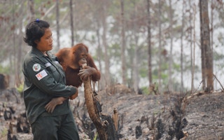
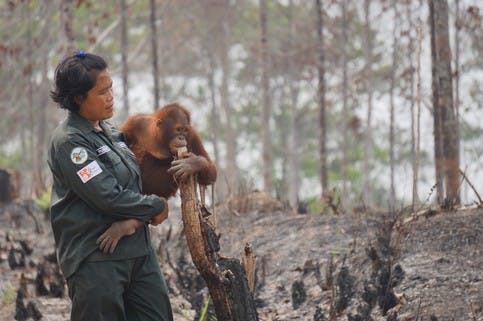
While the haze has kept people in their homes, it has also put a spotlight on wildlife whose habitats have been destroyed by the forest fires.
One of these groups is wild orangutans, a critically endangered species surviving in one of the last remaining forests in Kalimantan’s Gunung Palung National Park. The forest park has become an ecological island in Borneo after peatland surrounding it was converted to plantations.
Another group is Sumatran tigers, whose home in Tesso Nilo National Park in Riau, Sumutra, has also experienced widespread fires.
Meanwhile, in East Kalimantan, forest fires razed nearly 190 hectares of rehabilitated forests in Samboja Lestari last month, non-profit organisation Borneo Orangutan Survival Foundation (BOSF) said on Monday.
After 30 hectares of BOSF’s Orangutan Reintroduction Centre in the area caught fire in early September, another fire on September 23 spread at the organisation’s new orangutan enclosures, which fortunately was still empty, BOSF said in a statement.
However, when the fire changed direction, it headed towards BOSF’s 159 hectares of land that was planted with more than 750 endangered tree species meant for conservation and research, it added.
“We lost a significant part of that land through this fire outbreak,” it noted.
Orangutan habitats lost to forest fires in Samboja Lestari in East Kalimantan. Image: BOSF
The foundation is seeking help to save orangutans habitats. “Forest fires have severely damaged or cleared large swathes of orangutan habitat across Kalimantan. Our teams are still fighting fires to protect orangutans and natural habitat and we need basic equipment such as rakes, hoes, water pumps and hose, goggles, masks and protective clothing,” BOSF posted on its website on Wednesday.
Bustar Maitar, Indonesian forest project leader for Greenpeace, said the Indonesian government can no longer turn a blind eye to what is happening on the ground, as the implications affect communities as far as those in Thailand and possibly, Philippines and Cambodia.
“As governments prepare to meet in Paris to save the world from catastrophic warming, the earth in Indonesia is already on fire. Companies destroying forests and draining peatland have made Indonesia’s landscape into a huge carbon bomb, and the drought has given it a thousand fuses,” stressed Maitar.
The United States space agency NASA also captured several satellite images of the hotspots in Sumatra and New Guinea on September 22 and 24, respectively.
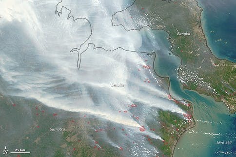
NASA’s Aqua satellite collected this natural-color image with its Moderate Resolution Imaging Spectroradiometer (MODIS) instrument on September 22, 2015. Actively burning areas, detected by MODIS’s thermal bands, are outlined in red. Caption and Image: Jeff Schmaltz LANCE/EOSDIS MODIS Rapid Response Team, GSFC.
Dozens of fires burning across the island of New Guinea, accompanied by heavy plumes of gray smoke, were captured by a NASA satellite image on September 24, 2015.
The haze has blanketed Papua New Guinea and has reached the Mariana Islands, about 2,500 kilometres to the north, according to media reports.
“The lack of rain and increasing warmth in this region as a result of El Nino may contribute to a greater outbreak in wildfires,” NASA noted.
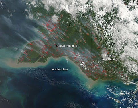
The Moderate Resolution Imaging Spectroradiometer (MODIS) aboard NASA’s Aqua satellite captured this true-color image on September 24. Actively burning areas, detected by MODIS’s thermal bands, are outlined in red. Most of the smoke rising from these hot spots are blowing towards the northwest. Caption and Image: NASA/ Jeff Schmaltz, MODIS Land Rapid Response Team, NASA GSFC
There are no established reports that link the wildfires to deliberate forest clearing for plantations in New Guinea. However, commercial agriculture in the area has been reportedly encroaching on forests recently.
Agribusiness giants Cargill and Singapore-based Golden Agri Resources promised in June this year to investigate one of its big suppliers, PT Eagle High Plantations Tbk, for possibly violating the firms’s no-deforestation policy after a report released by forest group Greenomics-Indonesia. The report documented the clearing of high carbon stock forests in South Sorong, a regency in West Papua, Indonesian New Guinea by Eagle High’s subsidiary, PT Varia Mitra Andalan.
Unilateral policies have failed to curb deforestation, Bustar’s Greenpeace noted, and he urged companies to impose an industry-wide ban on trade with any firm involved in clearing forests.
He commented: “These fires are a harsh reminder of the pulp and palm oil industry’s legacy of destruction. Companies need to rise to the challenge and work together to break the link between commodity production and forest destruction.”


