For many of us, these summer months offers a brief respite from the road congestion that burdens drivers and cities in the US and around the world each day. In a few short weeks, the less crowded highways, trains and buses will be a distant memory for most commuters.
Whether you live in Northern Virginia like me, New York, Nairobi, Nice, or you name it, cities are struggling to manage and prepare for short- and long-term traffic congestion.
Road congestion and the ensuing traffic jams aren’t just inconvenient; they can impede economic growth and impact the environment.
By decreasing congestion and increasing travel speeds so that 10 percent more people have access to certain areas, local production of goods and services could increase by one per cent, potentially generating tens of billions of dollars, according to a Reason Foundation report.
Intuitively, it’s something we might have already known — imagine how much more productive people are when they’re not stuck in their cars or on the bus several hours per day.
The good news is that help is on the way.
In fact, some cities are beginning to embrace and develop a holistic approach to improving their transportation infrastructure — from understanding where transit routes should be located to optimizing traffic flow and lowering emissions citywide.
Roadways and transit networks are filled with lanes of data that can be used to reshape traffic patterns to reduce congestion. Insight from road and vehicle sensors, smartphones and GPS devices, video and tolling systems, weather conditions, and more can be used to build more intelligent transportation systems to that use analytics to improve mobility and reduce congestion.
The beauty of this is that it doesn’t require massive capital investments like additional lanes on a highway or a road might.
For example, the city of Lyon, France has instituted a program called L’Optimod to help it achieve its urban mobility and sustainability goals, reducing the use of private cars by eight per cent and reducing CO2 emissions by 200,000 by 2020. Among the variety of efforts the city has undertaken is a pilot with IBM to create the traffic management center of the future.
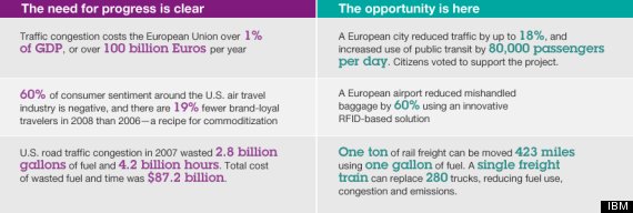
With access to real-time decision support on steps to reduce traffic congestion, officials can enable faster incident response time when an unexpected event or accident occurs. They can proactively manage the resulting traffic congestion, resulting in less time stuck in a traffic jam. Detours could more quickly be put into place, more accurate alternate route suggestions would be available, public transit schedules could be altered or first responders could get to an emergency more quickly.
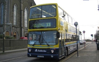
In Dublin, Ireland, the Dublin City Council is using data from its bus network, streaming in from an array of sources — bus timetables, inductive-loop traffic detectors, and closed-circuit television cameras, GPS updates that each of the city’s 1,000 buses transmits every 20 seconds — and build a digital map of the city overlaid with the real-time positions of Dublin’s buses using stream computing and geospatial data. Doing so allows them to determine appropriate traffic calming measures and to identify the cause of a delay as it is emerging and before it moves further downstream.
The same sensors on your car that alert you to low tire pressure or a broken taillight can also register sudden and heavy braking or sliding or hydroplaning on a slippery road. These events and tens of million data points, recorded when a vehicle is driven can be analyzed to help determine if a pothole or black ice could be the cause of the sudden action. It is can also be shared with traffic and road maintenance officials to monitor and fix road conditions in real time.
Several cities also are tapping into social listening tools to learn what improvements commuters want and how they can build more sustainable transportation networks.
Although it may be impossible to eliminate traffic altogether, we have the technology to combat it. In many cities, adding capacity to freeways is not an option because it’s either too expensive or too time consuming. And in many cases where capacity has been added, it typically increases congestion since more people feel encouraged to drive.
In the meantime, data analytics is a cost-effective tool that can make a dramatic difference. More often than not, the data is already available, it’s just screaming to be used.
With the aid of powerful analytic tools, transportation authorities are beginning to move away from a reactive approach to one that uses analytics to predict and avoid harmful congestion and traffic jams — before they occur.
Naveen Lamba is the associate partner for Smarter Government, Transportation, and Public Safety of IBM Global Business Services. This post originally appeared here.


