Water and air temperatures and shifts in wind patterns conspired to hold down sea ice extent, setting record lows for the month of November in both the Arctic and the Antarctic.
“It looks like a triple whammy – a warm ocean, a warm atmosphere, and a wind pattern all working against the ice in the Arctic,” said Mark Serreze, director of the National Snow and Ice Data Center in Boulder, Colorado, in a statement.
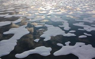
The NSIDC tabulates satellite data on the extent of sea ice around the poles, adding to a 38-year satellite monitoring project. Usually, around this time of the year, dropping temperatures in the run-up to winter help Arctic ice freeze, a process that typically starts in September and peaks in March. Instead, at one point in mid-November, the extent of the sea ice had actually contracted by about 50,000 square kilometers (19,300 square miles).
In some places, air temperatures topped out at 10 degrees Celsius (18 degrees Fahrenheit) above the averages recorded in November from 1981 to 2010. Consequently, the extent of the sea ice dipped to 9.08 million square kilometers (3.51 million square miles), nearly 18 percent lower than the November average.
Warming of the sea around Svalbard, an Arctic archipelago, had apparently stopped the freezing of ice altogether, said NSIDC scientist Julienne Stroeve in the release. Sea-surface temperatures in the area were up to 4 degrees Celsius (7 degrees Fahrenheit) higher than normal.
“Typically sea ice begins to form in the fjords at the beginning of November, but this year there was no ice to be found,” said Stroeve, who was in Svalbard last month.
“
It looks like a triple whammy – a warm ocean, a warm atmosphere, and a wind pattern all working against the ice in the Arctic.
Mark Serreze, director, National Snow and Ice Data Center
Though the Arctic data is jarring, it follows a trend for the year: November was the seventh month of 2016 with record-low levels of sea ice.
What’s striking is the parallel decline in sea ice extent at the opposite end of the globe, NSIDC scientists noted.
“The Arctic has typically been where the most interest lies, but this month, the Antarctic has flipped the script and it is southern sea ice that is surprising us,” said Walt Meier, a NASA and NSIDC affiliate scientist, in the statement.
With 2- to 4-degree Celsius (4- to 7-degrees Fahrenheit) spikes in air temperatures for this time of year and shifting winds that have moved around parts of the Antarctic ice pack, sea ice around the continent dropped precipitously in early November, to an average of 14.54 million square kilometers (5.61 million square miles). That’s 1.81 million square kilometers (699,000 square miles) below average, an area larger than Libya.
“Antarctic sea ice really went down the rabbit hole this time,” NSIDC lead scientist Ted Scambos said.
This story was published with permission from Mongabay.com.