The industry association for sustainable palm oil announced on Friday that it will make its members’ concession maps public, in a bid to improve the monitoring and enforcement of its rules for environmentally and socially responsible cultivation.
To continue reading, subscribe to Eco‑Business.
There's something for everyone. We offer a range of subscription plans.
- Access our stories and receive our Insights Weekly newsletter with the free EB Member plan.
- Unlock unlimited access to our content and archive with EB Circle.
- Publish your content with EB Premium.
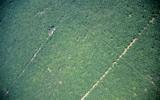
After two years of legal uncertainty, the Roundtable on Sustainable Palm Oil (RSPO) said that by the middle of next year, it will publish digital maps of all its members’ palm oil concessions except those in Malaysia, where it is not legal to do so yet.
The maps will be published on the Global Forest Watch online portal (including applications for Commodities and Fires), which is managed by US-headquartered non-profit World Resources Institute.
Green groups agreed that this move marked some progress towards transparency, but maintained that it did little to solve the wider problem of unsustainable palm oil practices.
Annisa Rahmawati, forest campaigner, Greenpeace Indonesia, said that many of RSPO’s non-grower members continue to buy palm oil from firms which are not RSPO members, and therefore have no obligation to make their maps public. She cited edible fat processing firm IOI Loders Croklaan as an example.
“As long as RSPO members continue to trade in oil from non-RSPO members which cannot be monitored, the impact will be very limited,” she said.
The palm oil industry was widely blamed for the forest and peatland fires in Indonesia from July to October this year, which led to the worst haze season on record.
Campaigners and members of the public alike called for the companies responsible for the burning to be identified and penalised, but doing so was difficult because there are no updated, definitive, and publicly available maps of oil palm concessions in Indonesia today.
The best available information is hosted on Global Forest Watch Fires, which overlays palm oil and paper concession maps with detected hotspots, but many of the maps for Indonesia are between three and five years old. The first batch of maps was obtained from government maps, which were public at the time.
They have not been updated since about 2010, due to recent changes in Indonesian and Malaysian law which raised questions about the legality of making concession maps public.
RSPO, which in 2013 passed a resolution asking all its members to submit their concession boundaries in a digital boundary known as shapefiles, submitted some updated maps to the GFW portal in 2013.
But this resolution was later disputed by members, who claimed it was not legal to publish maps according to Indonesian and Malaysian law.
So even though RSPO has collected new maps from 62 out of 102 members in 2014, none of this is reflected on GFW, which only has data from 2013.
But “after taking legal advice and extensive discussions with key stakeholders”, RSPO has confirmed that it is legal to publish Indonesian and other maps, except for Malaysia, said the association in a statement.
An RSPO spokesperson explained to Eco-Business that in Malaysia, concession maps represent “commercially sensitive information”, and therefore have been classified under the country’s Official Secrets Act.
But this is not the case for Indonesia - the world’s biggest palm oil producing nation - and lawyers from the country advised RSPO that it could safely publish the maps.
Greenpeace’s Rahmawati called on RSPO to clarify what actions will be taken against companies who have not submitted shapefiles of their maps but rather paper printouts, or worse, not provided maps at all.
While RSPO did not publish these details, it noted that “fire monitoring activity is seriously constrained by the lack of a single, credible and up-to-date database of palm oil concession maps”.
Disclosure of map data by RSPO members was identified as the best currently available source of information to map land ownership of palm oil plantations,” it added.


