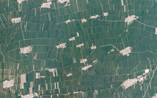
Employing satellite imagery in the agriculture sector is not new; organisations have been utilising images from space to study land-use ever since the first satellite of NASA’s Landsat program started beaming back pictures in 1972.
Yet until recently what those satellite images could be used for was relatively limited. That was partly due to issues with the resolution and frequency of these images, but also because of an inability to assimilate this potentially valuable data into the day-to-day operations of a typical farm.
“Agriculture has always been well suited to satellite technology,” says Zara Khan, director of business development at Planet, a leading global provider of satellite imagery. “The difference between then and now is that the data we’re generating is able to be integrated into all the additional innovations taking place on the farm.”
Khan is referring to the rise of precision agriculture, the theory of incorporating innovative technology like remote sensing, robotics, machine learning and the Internet of things (IoT), as well as satellite imagery, into agricultural practices.
With its data-driven approach, precision agriculture offers the opportunity for greater efficiency, yet the biggest challenge is ensuring that the data and the technology can work together seamlessly.
Helping to make data integration possible is where a range of third-party companies such as the Asia-based EOfactory.ai come in. Over the last eight years, their Geographic Information Systems (GIS) have been helping ensure that customers in a range of sectors, including agriculture, are able to fully leverage the benefits of satellite imagery.
“
The difference between then and now is that the data we’re generating is able to be integrated into all the additional innovations taking place on the farm.
Zara Khan, business development director, Planet
“The advantage with satellite images is it is near real-time data and can cover a large area in a short time,” says Abhay Swarup Mittal, chief executive of EOfactory.ai, who points out that they also eliminate the need for costly manual data collection and the potential for human error.
EOfactory.ai’s GIS systems combined backend processing power and machine learning technology to process the large amounts of data obtained by satellites to map out information relating to different crop types quickly and accurately.
“Using our solution is a one-stop combination of applications where processing, analysis, and results can be carried out all in one place,” explains Mittal.
What’s more, EOfactory.ai are able to customise the solutions offered to ensure they meet the different requirements and challenges faced by a range of different stakeholders from farmers, crop insurers and seed companies all the way through to government departments. Through a user-friendly front-end dashboard, customers can access the different analytic data at the level that suits their decision-making needs, be that at a village, sub-district, province or a country level.
That client customisation can also include the spectral, spatial, and temporal range of the satellite imagery offered. An image tool kit allows users to choose functionality such as haze removal, image correction or a mosaic option which can build up a cloud-free composite map, particularly important in countries like India where the majority of crops are grown in the Kharif (Monsoon) season.
A field survey mobile application FarmVigil, has helped clients streamline the gathering of additional farm data such as planting dates and fertiliser usage into the GIS, while back end processing platforms like Rolodex and Pixel Magic ensure the solution can handle high volumes of data and high processing speeds. Put together, it helps to remove the need for multiple software applications and a potential reliance on software experts.
EOfactory.ai have now developed a range of sector and site-specific solutions that can help evaluate land zoning and crop site suitability, monitor crop health, predict yields and estimate crop production and acreage, as well as assess levels of crop damage. These solutions have also been developed to cover a wide range of crops including maize, rice, wheat, cotton, soybean, groundnut, sugarcane, mustard and cashew.
Utilising this technology has helped a variety of end users across Asia. In India, agri-traders have been able to estimate state-by-state wheat yields 30 days ahead of harvest, giving them an advantage in terms of procurement and storage plans. Also, in India, insurance companies have started using satellite imagery to assess the extent and intensity of crop damage when resolving payment claims. Meanwhile, in Indonesia, remote sensing has been combined with machine learning algorithms to automatically assess the growth rates of rice paddies.
“
How do you know which paddock to graze next? How do you know how much pasture is in a paddock? How do you know how much grass a cow can eat? The issue is that nine out of 10 farmers don’t have an answer to these questions.
Oliver Roberts, founder, Pasture IO
Pasture.IO is another real-life example of how satellite imagery can work with other technologies to answer a specific agricultural challenge. The pasture management platform was born out of its creator Oliver ‘Ollie’ Roberts’ attempts to answer some very basic questions on his own family farm in NW Tasmania.
“How do you know which paddock to graze next? How do you know how much pasture is in a paddock? How do you know how much grass a cow can eat?” recalls Roberts. “The issue is that nine out of 10 farmers don’t have an answer to these questions.”
Given responsibility for managing where the farm’s herd of 500 cattle should graze, he set out to develop a more scientific approach to replace the “gut instinct” traditionally used by farmers. The result was a bootstrap platform that allowed him to better monitor the quantity and growth rates of pasture for each individual paddock.
Fast forward 15 years and the much-refined platform now incorporates weather data, satellite imagery and farming records (fertiliser usage, planting, harvests, etc) into a machine-learning environment which can develop specific pasture management models for individual farms. They currently help clients (predominantly dairy farms) from Australia, New Zealand, South Africa, the United Kingdom, and the Americas.
“They recognise there is a massive benefit to recording data, but in the past it was how they could fit that in alongside all the other demands of being a farmer,” explains Roberts, who acknowledges that the need to go out and manually measure pasture growth in each field was originally a barrier for farmers adopting early iterations of Pasture.IO.
It was a barrier they looked to overcome through first getting access to Planet’s satellite imagery through a partner company in 2019, before they moved to source the data directly from Planet in 2020. Accessing their high resolution satellite imagery and feeding that data into a machine learning system alongside farmers records and atmospheric information, they are now able to automatically measure pasture growth and to predict potential pasture yields, not just for each paddock but also at the intra-paddock level.
Unlike other less frequent options, Planet’s constellation of satellites also ensures paddocks are measured nearly daily, invaluable in eliminating the potential issue of cloud cover; important as most of Pasture.IO’s clients are based in temperate high rainfall areas.
By offering a clear and detailed overview of outcomes for the whole farm, the system allows farmers to make tactical management decisions around water use, stocking rates, purchase of seeds, fertiliser and more. As Roberts puts it, the aim is to help support or even remove the daily decision-making burden on farmers and allow them to farm more efficiently.
Being able to better understand the inputs required to manage their pasture has a clear economic benefit. A 2018 study in New Zealand by Beukes et al. estimated that a farmer could make an additional NZ$500/ha when a paddock’s herbage mass (amount of pasture) is accurately known. That can amount to an additional NZ$110,000 to $160,000 for a 300ha farm, which is not insignificant in an industry known for its tight margins.
Satellite imagery can also help in managing the natural environment within and around farms, important as farmers strive for more sustainable agricultural practices. Yield maps can allow for better targeting of fertiliser applications, so reducing the risk of contamination. Spatial analysis can ensure better understanding of riparian zones and areas of natural shelter for livestock and wild animals, allowing farmers to fence off environmentally sensitive locations and in turn reduce the risks of inter-species disease transfer.
By analysing how specific areas of a paddock are performing, farmers can potentially alter boundary lines, reducing the need to constantly move livestock from field to field. Not only does this mean less stress for the animals but it also alleviates potential pressure on grazing lands, protecting them for future generations.
“It [satellite imagery] allows greater geospatial analysis that leads to protecting native flora and fauna, reducing the carbon footprint and increasing the efficiency of operations,” states Roberts.
There might also be one other currently untapped benefit to adopting this technology-driven approach, relating to issues around food security. With consumers and governments demanding greater transparency in the supply chain, platforms like Pasture.IO already offer credible, ready-made records in terms of grazing management and individual farm compliance.
“It’s the way of the future,” concludes Roberts when describing the value of this more transparent and more efficient approach to farming. “Social and economic sustainability just can’t exist without us embracing sustainable environmental practices,” he says.


