With all of the environmental problems in the world, it can be easy to forget that there are also many solutions. Across the globe, people are working to restore nature, and good ideas abound. Organising and visualising this work, however, is a mammoth task, but it is one that the online platform Restor is attempting to achieve.
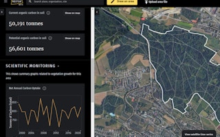
Restor is a map-based, open-source platform that combines on-the-ground knowledge, ecosystem research, and satellite imagery so people can better plan, manage and monitor restoration projects.
The locations of more than 50,000 restoration and conservation initiatives are now registered in Restor, as well as data from more than 60,000 scientists on environmental parameters such as climate, temperature, precipitation, local plant and tree species, soil characteristics and more.
“Restor will make the whole world of environmental conservation and restoration accessible on any smartphone,” Thomas Crowther, a professor at the Swiss Federal Institute of Technology in Zürich (ETH Zürich) whose lab group developed Restor, said in a press release. “We did this by developing a kind of Google Earth to guide the restoration of all types of Earth’s ecosystems.”
The idea for the platform originated in the Crowther Lab at ETH Zürich in 2017, where researchers create maps of global ecosystems using machine-learning models, field data, satellite imagery, and environmental information. In 2020, in collaboration with Google, the Crowther Lab began working with scientists, communities and environmental groups to expand Restor into a functioning online ecosystem. Headquartered in Switzerland, Restor is now its own organisation and is owned by a charitable foundation.
“Restor combines networking, monitoring, and information exchange in one dynamic and comprehensive visual platform, filling a huge gap in the practice and policy of restoring ecosystems around the world,” Robin Chazdon, a global restoration expert from the University of the Sunshine Coast in Australia, who was not involved in the creation of Restor, told Mongabay in an email.
“
Our goal is to incentivise increasing project transparency so that, over time, the quality of projects increases and both good and bad practices are easier to identify.
Clara Rowe, CEO, Restor
Using the platform, Restor users can view regions of the Earth at a resolution of up to 50 centimetres (20 inches) and learn about their potential for restoration or conservation. The Crowther lab has even developed a model that allows researchers to determine what tree species are native to a particular location to serve as a useful guide for reforestation efforts.
Currently, Restor is collecting data from restoration projects around the world. Anyone with a project can apply for access to the site where they will be able to enter data about their project and ecosystem. The project managers have the option of whether their projects are saved publicly or privately. All of the public data will be made available to the public on the platform in October, as part of the TED countdown event.
Restor is not in the business of verifying or validating the projects on the platform. Instead, it’s opting for a low barrier to entry in order to collect as much data as possible.
“We want to build a place for everyone, and that includes projects that may be struggling,” Clara Rowe, CEO of Restor, told Mongabay in an email. “Our goal is to incentivise increasing project transparency so that, over time, the quality of projects increases and both good and bad practices are easier to identify.”
Some limitations of the platform, Rowe says, are that not all projects have the same resolution and accuracy of data. Also, no social data are included in the platform, such as land tenure for local communities or Indigenous groups.
Because there is no single, global source or database of land tenure data and traditional land tenure is not respected by governments in many parts of the world, it is difficult to collect and standardise this kind of information on a global platform. However, Rowe says, they will continue to think through ways to incorporate social data, which are critical to the success of restoration.
Rowe says their goals are to continue to make the platform easier to use, to make more connections between practitioners, connect projects to funders and volunteers, and bring scientific insights to decision-makers.
“My biggest hope for Restor is that we can enable and accelerate ecological restoration — of all ecosystem types — around the globe by making it easy for anyone, anywhere to engage,” Rowe said.
“If restoration is going to become a global movement, as many of us hope,” Chazdon said, “we need platforms like Restor to showcase where initiatives are taking place, who is implementing them, what they are doing, what their needs are, and how well the work is progressing. Efforts small and large are all important and can all benefit from engagement with the Restor platform.”
This story was published with permission from Mongabay.com.