The University of the Philippines (UP), in partnership with the Department of Science and Technology, is using laser scanners inside manned airplanes to create high-resolution hazard maps and a flood advisory system that will enable decision makers in the typhoon-prone country to come up with new strategies for disaster risk management.
The programme, which started in January 2012, is called Disaster Risk and Exposure Assessment for Mitigation (DREAM) and is unique in South-East Asia.
The Philippines owns and operates the whole system — from flying the plane to operating the scanners — and has a young, dedicated workforce with the skills to sustain the programme in the future. The average age of the 140-person DREAM team at UP is just 27.
The data gathered, starting with the hazard maps, will also all be open source and downloadable online.
“That infrastructure is very, very important,” Dinand Alkema, an assistant professor in earth systems analysis at the University of Twente in the Netherlands, tells SciDev.Net. “Other countries in the region would just hire a foreign company to do the work then offer the final dataset, which is just a tiny fraction of the information. (But) the Philippines has it all now.”
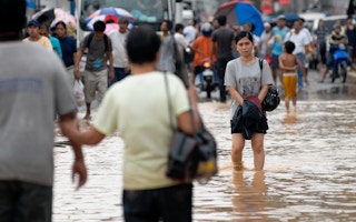
Current hazard maps in the Philippines indicate that almost 87 per cent of the country’s 300,000 square kilometres of land is disaster prone but do not provide further detail. “They don’t convey practical information,” Enrico Paringit, DREAM programme director, tells SciDev.Net. “You can’t act on it.”
Paringit then offers a refined hazard map on his laptop. DREAM intends to focus on over 250 major rivers in the country based on economic activity or their propensity to flooding, creating about three types of maps for each of the rivers and their surrounding areas. In 2014, Paringit and his team partnered with 14 state universities in the Philippines, bringing the total number of people working on DREAM to roughly 700. The project is slated to be completed by the end of 2016.
Light and radar detection and ranging (LiDAR) instruments were used to collect the data needed to make the updated flood hazard maps. The process is simple: the LiDAR equipment is put on a plane where it scans the topography by sending millions of pulses per second to the ground, which bounce off it and are caught by a sensor.
The data is then transported via hard drive to the DREAM office at UP for analysis. Team members are particularly interested in identifying low-lying vulnerable areas since different sectors and government agencies are now using the data. For instance, local governments are using these to implement better zoning laws based on scientific evidence.
Lidar can send up to hundreds of hits per square metre, which create an extremely precise representation of the Philippines’ topography and everything in it, including cars, trees and people. According to Paringit, the resolution is accurate up to 20 cm, which is better than the images produced by most satellites.
To verify the data, members of the DREAM team are sent out on the ground to map the terrain for surveying. They get local communities involved in the procedure to familiarise locals with the technology and give them a sense of ownership. Using LiDAR, the information is then compared to the data gathered.
Back in the Manila offices, a quality specialist looks at the work produced by one of the analysts. The information presented by the DREAM programme is accurate 85 per cent of the time, estimates Paringit. Other South-East Asian countries such as East Timor and some small Pacific island states are now asking the Philippines for advice on using LiDAR.
“This is part of the inclusive growth that we’re trying to pursue,” says Paringit. “You don’t leave out the small communities.”