Nothing about the 292,000 hectares of acacia plantations established on the Kampar Peninsula – one of Southeast Asia’s largest peat domes – can be considered sustainable, says a recent report commissioned by the NGO Wetlands International.
The “business as usual” approach to draining peatlands for plantations is resulting in widespread subsidence – sinking – and carbon loss, the study finds. This will eventually render the land unsuitable for agricultural or community use as flooding becomes increasingly widespread and unmanageable.
The report, conducted by the Netherlands-based consultancy Deltares, combines field-samples with laser scanning LiDAR imagery and elevation models to conclude that plantation lands on the Kampar Peninsula will eventually subside below flood levels, leading to widespread abandonment.
Further, the draining causes peatlands to collapse and decompose, releasing large amounts of carbon into the atmosphere, while opening the land to the threat of uncontrollable fires – like those that burned across Indonesia last year during the devastating haze crisis.
Asia Pacific Resources International Limited (APRIL), Indonesia’s second-largest pulp and paper company, controls the balance of plantation land on the peninsula, holding permits to 220,061 hectares of peatland – over 70 per cent of which has already been converted to drained, productive acacia monoculture.
This is roughly a third of APRIL’s total plantation holdings. Its main competitor, Asia Pulp & Paper, has similarly developed 72 per cent of its 72,598 hectares of permits on the peninsula.
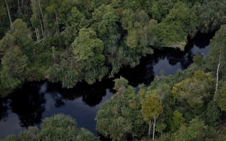
Sprawling over nearly 700,000 hectares in eastern Sumatra, the Kampar Peninsula has an average minimum peat depth of 4.9 meters (16.1 feet). Some areas exceed 7 meters deep – though the researchers caution that they likely underestimate the depth by several meters.
This dense mass of organic material contains a massive below-ground carbon stock in addition to the forest carbon growing above. Biodiversity surveys conducted by the NGO Flora and Fauna International have found an impressive array of wildlife on the peninsula, including 77 IUCN Red List species, and five of the six wildcat species found in Sumatra.
According to some estimates, the peninsula could support a population of 60 Sumatran tigers (Panthera tigris sumatrae), or 15 per cent of the remaining population. The peninsula has long been labeled a “Biodiversity Hotspot,” “Regional Priority Tiger Conservation Landscape” and “Important Bird Area” by various local and foreign NGOs including WWF and Conservation International.
The peninsula was relatively untouched at the turn of the millennium when Indonesia’s forestry ministry began issuing permits to convert the land into industrial plantations. Many of the licenses were granted with the idea of forming a “ring” of plantations around the peninsula’s pristine core in an attempt to create a buffer against illegal logging and encroachment. This controversial plan angered some environmental groups who felt developing peatlands under the guise of protecting other peatlands was an unacceptable alternative to simply enforcing existing protection laws.
By 2014, 43.4 per cent of the peatlands on Kampar Peninsula had already been drained and converted to acacia plantations, with an additional 10.9 per cent converted to oil palm.
In order to plant acacia – the rapid-growing tree used for paper pulp and wood fiber – on peat soil, the naturally saturated swamp must first be drained. Acacia is most productive when water levels are maintained between 70-90 centimeters below the surface, a condition achieved via an extensive network of drainage canals.
Invariably, when the swamp is drained, the drying organic matter rapidly compresses and decomposes. Where the land is converted to agricultural uses, the addition of fertilizer and the mechanical disturbance further catalyzes the decomposition, a major contributor to subsidence.
The decomposition also causes the release of carbon into the atmosphere. The study authors estimate that the peninsula contains 1.6 gigatons of carbon, an amount equivalent to burning 13.6 billion barrels of gasoline.
The carbon is more rapidly – and more noticeably – lost during fire events like those seen during the 2015 dry season throughout Sumatra, Kalimantan and Papua. All of the recent fires on the Kampar Peninsula occurred within drained plantation areas.
In addition to the massive carbon emissions, as the peat dome sinks the natural hydrology of the land is altered. Runoff after heavy rain events is slowed, causing prolonged flooding events. Ultimately, as the edges of the dome sink below the high water level of the bordering rivers and sea, more frequent and longer-lasting floods will inundate the plantations, eventually drowning the crops.
“Eventually, subsidence often brings the land surface to an elevation where flood risk is high, drainage of excess rain water by gravity is impeded and flooding by river or sea water becomes possible,” the authors write.
Indeed, this is already occurring.
According to the study, in 2014 31 per cent of existing plantations on Kampar were already experiencing flooding. Maintaining the “business as usual” drainage depths of 40-90 centimeters, the authors predict that 83 per cent of the land will experience significant flooding in 50 years, with 98 per cent becoming unproductive in 100 years.
To help mitigate the rate of subsidence, companies such as APRIL have begun adopting new management practices, maintaining a wet-season water level of 40 centimeters below the soil surface. This 40-centimeter standard was also dictated by Indonesia’s peatland protection laws, and plantation companies have long protested against it.
However, the authors estimate that maintaining the higher water levels will only reduce the rate of subsidence by 20 per cent dropping to a rate of 3.5 centimeters per year.
“Improved water management may lengthen the lifetime of the whole area under production but this is generally by much less than 25 years,” the authors write, “and in all cases, the whole plantation area is affected by drainability and flooding problems within 150 years for both the ‘Business As Usual’ and ‘Best Management Practice’ subsidence rates.”
“The implication,” the authors conclude, “is that peat loss in tropical peatland that is used for agriculture will likely always be substantial, even in the hypothetical case that water levels are brought up close to the surface.”
In a open letter to APRIL sent in relation to the Deltares report, Wetlands International called on the pulp and paper giant to “phase out” its drainage-based plantations on the peninsula, a process that “should involve restoring hydrological conditions of currently drained concession areas on peatlands and the identification piloting and upscaling of the use of alternative crops that require no drainage.”
Lucita Jasmin, APRIL’s director for external affairs, declined to answer specific questions, but wrote in an email to Mongabay, “The Wetlands International report has offered a view which helps to enrich not only the scientific debate but also the policy discourse on the subject.”
However, she indicated that APRIL did not agree with the findings of the report, and said APRIL had been conducting an independent study that reached a different conclusion regarding the sustainability of its operations.
“APRIL has shared its [competing] view with the [company’s] Stakeholder Advisory Committee and with the newly established Independent Peat Expert Working Group,” Jasmin wrote. “This view was founded on and informed by actual data (not assumptions) from close to 15 years of monitoring and collecting on the ground and adopted the same modeling methodology as used by [Wetlands International].”
APRIL was not able to share its internal report with Mongabay at this time.
This story was published with permission from Mongabay.