Almost threequarters of a sample of island groups – atolls and archipelagos that are home to more than 18 million people − are expected to become increasingly more arid under a regime of climate change.
The new research implies a systematic underestimate of the plight of islanders as the world warms because of increasing levels of greenhouse gases in the atmosphere. It also poses another threat to the survival of island communities.
Poignantly, many of the islands are too small even to be included in climate science calculations. So the communities that have, historically, contributed least to global warming could become the most immediate victims.
Kristopher Karnauskas, assistant professor of atmospheric and oceanic sciences at the University of Colorado-Boulder, US, and colleagues report in Nature Climate Change that they took a fresh look at the world vision of climate projections and the assumptions made in calculating the impacts of climate change.
Water stress
Overall, as the world warms, some regions will become moister, some more parched. The impact on the islands would be about half and half: 50 per cent would see more rain, 50 per cent would feel water stress.
But the scientists found the “resolution” of such projections was too coarse to include many tiny spots that have always figured on naval charts. And many islands in Polynesia are too small to register on the climate map of the world, so an estimated 18 million inhabitants are, in effect, “computationally disenfranchised”.
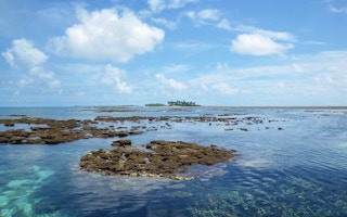
Even a dot on the map as famous as Easter Island a World Heritage Site in the South Pacific, and home to a set of vast, enigmatic statues that tell of a vanished culture − is deemed not to be there. The grid on the climate map that contains it is regarded as open ocean.
The islands of French Polynesia, the Marshall Islands and the Lesser Antilles are all among the most “water vulnerable” places on the planet, but they do not register at all on climate projection models.
It’s not as if islanders didn’t have problems already. Coral atolls are rarely more than two metres above sea level, and many are projected to disappear altogether under water as the sea levels rise − unless the world stops burning fossil fuels and switches to renewable energy on a massive scale. .
Even with limited sea level rise, their citizens face an uncertain future. If the ocean invades the groundwater and poisons their crops, before washing away their villages, it isn’t clear if inhabitants of the islands could technically qualify as refugees deserving of international help.
And the latest research brings no comfort. Even if more rain does fall, evaporation will also increase, so perhaps 73 per cent of the islands could become more parched as a result of increased evaporation.
Regional changes
“Islands are already dealing with sea level rise,” Dr Karnauskas says. “But this shows that any rainwater they have is also vulnerable. The atmosphere is getting thirstier, and would like more of that freshwater back.”
Climate scientists divide the world into grid boxes 240 km by 210 km to consider regional changes. If the area is almost entirely ocean, they consider it ocean and make predictions of change.
Altogether, the researchers say, there are thousands of islands too small to figure on the climate maps. The UN estimates the population of the Small Island Developing States to have been at 64 million in 2010. By 2100, it would be 80 million.
“Paper after paper in my field shows changes in drought or aridity, but my eye always looks at the maps and graphs in those papers and I wonder why we can’t see islands,” Dr Karnauskas says.
“Using models, it turns out, is much less straightforward for islands than for places where there are big chunks of land.”


