With their ability to absorb up to one third of all greenhouse gas emissions, trees play an essential role in the ongoing fight against climate change. Yet, according to data published by Global Forest Watch, the world’s tropical rainforests disappeared at a rate of one football pitch every six seconds in 2019.
That’s why the protection of tropical forests has long been a cornerstone of climate change policy, and an integral part of the 2016 Paris Climate Change agreement. Yet the very speed and scale at which deforestation can occur has traditionally made it extremely difficult to monitor and prevent.
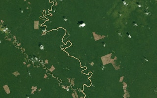
Starting back in the 1970s, with NASA’s Landsat missions, satellite imagery is one tool that’s been used to try to monitor, understand and fight deforestation for decades. However, traditional limitations in terms of the frequency and resolution of those images has previously restricted their effectiveness – too often the trees were gone before anyone had time to realise, let alone act.
But that’s changing, as new satellite technology, from the likes of leading satellite image provider Planet, have ushered in an explosion of remotely sensed earth observation data at much higher spatial and temporal resolutions. Landsat satellite images offered a image resolution of around 30 meters with very low revisit rates; in comparison, Planet’s satellite data provides 3.5-5 meter pixel resolution, monthly updates and global coverage.
“
Technology alone is not a silver bullet. It needs to be paired with science and on-the-ground local knowledge and expertise to have real and lasting impact.
Tara O’Shea, director of forest programmes, Planet
“For the first time, the data really reflects the pace and the scale that deforestation happens on the ground so it becomes much more actionable,” explains Tara O’Shea, director of forest programs at Planet.
That’s one reason why a new US$43million agreement, signed in September 2020 between the government of Norway and Kongsberg Satellite Services (KSAT) and its partners Airbus and Planet, has the potential to make such a difference when it comes to tackling deforestation.
Through Norway’s International Climate and Forest Initiative (NICFI), this deal offers universal access to high resolution and high frequency satellite imagery of tropical regions, home to some of the world’s most ecologically important and most threatened forests.
While the largest, the NICFI agreement is not the first partnership that Planet has undertaken in this sector. Indeed tackling the challenge of deforestation was one of the key considerations of the company’s founders when they formed Planet in 2010 with the vision of using space to help life on earth.
Since the beginning of 2019, they have been working with the United Nations Food and Agriculture Organization (FAO) to provide high resolution imagery from their DOVES satellite constellation data set for eight tropical countries: Chile, Colombia, Democratic Republic of the Congo, Costa Rica, Ghana, Indonesia, Mexico and Mozambique.
By plugging the relevant satellite data into SEPAL, a cloud-based analysis platform developed by the FAO to better track deforestation and land use, each country had a clear set of tools to track how they are progressing in their efforts to achieve their specific emissions targets, set under the UN’s Reduce Emissions from Deforestation and Forest Degradation (REDD+) programme.
For a country like the DRC Congo, this arrangement marked the first time that they had access to high resolution countrywide data on land use. Planet’s algorithm-led mosaic product, which stitches together monthly maps to provide the best composite available, helped serve up reliable and consistent images of this typically cloud-covered country.
A key part of Congo’s efforts to set up a National Forest Monitoring System (NFMS), the use of Planet data, integrated into SEPAL, also gave them a credible way to prove they were reducing emissions and demonstrate that they were eligible to receive performance-based payments under the terms of the Paris agreement.
The new NICFI deal helps to expand on the principles of this FAO/Planet partnership by broadening the number of countries from eight to nearly 100 for which relevant satellite data is freely available.
“The Norwegian partnership can start a million new partnerships,” states O’Shea of the potential value of the agreement, which initially runs until 2022 with an option to extend for an additional two years. “It really does solve the comprehensive global access problem for this particular use [studying deforestation].”
Those new partnerships have already started. For example, the FAO is looking to integrate Planet satellite imagery into a Near Real-Time (NRT) monitoring system in the Lower Mekong Region (including Laos, Cambodia and Myanmar). The aim is to create a system that can differentiate between timber that has been logged sustainably, compared to wood that is being extracted illegally.
In Peru, the Ministry of Environment (MINAM) and the Forest and Wildlife Service (SERFOR) have also taken advantage of the newly available high-resolution imagery, and the related archive which stretches back to 2015, to better adjust its estimates of deforestation for a 12-year period between 2007 and 2019.
As well as making data more accessible, making it free to everyone also removes the factor of cost, previously a major barrier to using satellite imagery for smaller stakeholders.
“Now anyone on the ground, including indigenous groups, a forest community, or a journalist, can look and visually interpret that information,” points out O’Shea.
This is already happening in South America where non-governmental organisation Amazon Conservation has taken Planet satellite data alongside GLAD Forest Alerts via Global Forest Watch (GFW) and integrated them into their Monitoring of the Andean Amazon Project (MAAP).
Using the composite maps generated by GFW’s open-source web application to enhance their real time monitoring programme, they have been able to track forest loss as it happens across the region. Last October and November they were able to identify the loss of 225 hectares of forest, most likely due to expanding cattle pastures in Colombia’s Chiribiquete National Park, while they are also working with local law enforcement groups to try and prevent ongoing deforestation caused by illegal gold mining in Peru.
The opportunity to improve existing forest monitoring systems by offering greater access to higher temporal and spatial resolution visual data is not the only potential benefit. The NICFI agreement also covers an additional layer of free downloadable analysis-ready data, corrected for atmospheric and surface reflectants.
As well as being something that scientists and policy makers can readily plug into their own analytical work environments (such as SEPAL), the data set is also being used by academic institutes to research potential new ways of monitoring deforestation.
O’Shea noted that satellite imagery data can be combined with other technological innovations, such as cloud computing and machine learning. “They’re helping us get better at understanding what all this information is telling us.”
She points to the work of Arizona State University’s Center for Global Discovery and Conservation Science as a pioneer in this field through their work in Peru around the monitoring of forest carbon stocks.
In the past, scientists would have to rely on a form of 3D modelling using Airborne Light Detection and Ranging (or LiDAR) data to estimate carbon stocks. This is difficult to do regularly or at scale, because it is costly.
The ASU team, led by Dr Greg Asner, has come up with a solution that can train their machine-learning model using a small sample of 3D LiDAR data. Once trained, the model can work in combination with Planet’s high-resolution 2D satellite imagery to make detailed estimates across a much wider area, in the case of Peru across the whole country.
The results were striking. According to the research, carbon emissions caused by deforestation in Peru were 24.3 per cent higher than previously reported by prior assessments. Not only did it highlight the unreliable nature of previous assessment methods, but reinforced the value of the remaining forests and the need for their protection.
While there is still a lot of work to be done in this field, it’s hoped that this kind of modelling could eventually result in the ability to directly measure the amount of biomass or stored carbon in an area of forest just from analysing satellite imagery.
With many arguing that forest-based carbon trading could be a key factor in the long-term protection of forests, this solution could present a more practical and affordable way of collecting valuable information. It could also offer a more credible and transparent approach to placing a real economic value on areas of remaining tropical forest.
But while the NCFI ambition of offering universal access to free satellite imagery is a big step forward in improving forest monitoring, it is still just a tool, not a solution to deforestation.
“Technology alone is not a silver bullet,” concludes O’Shea. “It needs to be paired with the science and on-the-ground local knowledge and expertise to have real and lasting impact.”