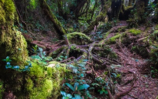
Malaysia is currently at risk of losing 16 per cent of its remaining forest cover due to concessions for timber and palm oil plantations, among other developments, according to new analysis by environmental watchdog Rimbawatch.
To continue reading, subscribe to Eco‑Business.
There's something for everyone. We offer a range of subscription plans.
- Access our stories and receive our Insights Weekly newsletter with the free EB Member plan.
- Unlock unlimited access to our content and archive with EB Circle.
- Publish your content with EB Premium.
The organisation’s State of Malaysian Rainforests 2024 report, published today, updated data from a year ago using a strengthened methodology. The area at risk of deforestation was found to have increased from 2.3 million hectares in 2023 to 3.2 million hectares this year.
“If this deforestation occurs, Malaysia’s forest cover will drop below 50 per cent of our landmass, thereby constituting a failure of Malaysia’s commitment to maintain 50 per cent forest cover,” Rimbawatch said in a press statement.
The overall 3.2 million hectares at risk of deforestation is nearly equivalent to the size of Pahang, Peninsular Malaysia’s largest state. Pahang is among the top states where concessions overlap with natural forests, after Sarawak, Sabah and Kelantan, Rimbawatch co-founder and director Adam Farhan told Eco-Business. Sarawak recorded a whopping 68.2 per cent of timber plantations in intact forests, more the four times that of the next highest state, Sabah (16.1 per cent).
Of all the concession types, monoculture timber plantations were found to be the primary threat to Malaysian forests. Three quarters of the at-risk forests are located in timber plantation concessions, while other threats include the degazettement of forest reserves, hydropower projects and palm oil plantations.
“Timber plantations refer to programmes supported by Malaysia’s forestry authorities to increase supply of timber. These plantations … involve the clearance of natural forests in forest reserves and their conversion to monoculture plantations, usually for rubberwood or acacia,” said Rimbawatch.
While such plantations have been promoted by state authorities as a way to “restore” degraded forests, the data showed that only 38 per cent of forests in timber plantation concessions are degraded, with the majority classified as “undisturbed forests”. Rimbawatch used ArcGIS to analyse the data, measuring the European Union’s Tropical Moist Forest cover data set, a tool used to support the EU Deforestation Regulation, against Malaysia’s concession boundaries.
Worryingly, the watchdog said that due to official definitions of forest cover that are based only on legally gazetted areas such as forest reserves, much of the deforestation could go unreported. “Official data remains untransparent,” Rimbawatch said, pointing out that Malaysia does not publish geospatial data of its official forest cover statistics and that timber concession maps are outdated.
Not only will the clearance of Malaysian forests jeopardise its forest cover commitments, it also threatens the country’s biodiversity and ecological functions, as well as its commitment to achieving net-zero greenhouse gas emissions by 2050. The clearance of 2.4 million hectares of timber plantations alone would release 368 million tonnes of carbon dioxide into the atmosphere, equivalent to a year’s worth of emissions from the United Kingdom, Rimbawatch said.
“Rimbawatch makes an urgent call based on these findings for an immediate end to all conversions in forest reserves for timber plantations,” it added.
Rimbawatch’s new report comes just weeks after it launched a new tool to track deforestation in Malaysia. Dubbed the “Forest Tracker”, it allows users to track past and projected deforestation in Malaysia, with different land-use layers, including oil palm, timber plantations, mining, infrastructure and other commodities.
According to Rimbawatch, the Forest Tracker is the only comprehensive database for Malaysian forest concessions, covering all deforestation-risk sectors, and is also the only publicly available collated dataset on Indigenous traditional territories across the country. The data indicates that some lands claimed by Indigenous communities also overlap with known concessions.
“As the government continues to hide data related to environmental impact assessments, the location of oil palm plantations, forest reserves, forest cover and others; we hope that by publishing this map we are, as a citizen-led initiative, fulfilling the right of the public to information,” Adam had said.
Rimbawatch has been vocal about Malaysian authorities’ lack of transparency towards official forestry and land use data, including the continued unavailability of full environmental impact assessment reports.


