As countries around the world begin to either propose or enforce zero-deforestation regulations, companies are coming under growing pressure to prove that their products are free of deforestation. But this is often a far from straightforward process.
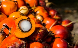
Take palm oil, for instance. Its journey from plantations, most likely in Indonesia or Malaysia, to store shelves in the form of shampoo, cookies or a plethora of other goods, is a long and convoluted one. In fact, the cooking oil or cosmetics we use might contain palm oil processed in several different mills, which in turn may have bought the raw palm fruit from several of the many thousands of plantations.
For companies that use palm oil in their products, tracing and tracking its origins through these obscure supply chains is a tough task. Often it requires going all the way back to the plot level and checking for deforestation. However, these plots are scattered over vast areas across potentially millions of locations, with data being in various states of digitisation and completeness.
“We need to be able to trace these plots to the facilities that ultimately are used for processing the crop into commodities which are sold in one of these regulated-demand markets,” Leo Bottrill, CEO of MapHubs, a technology company that uses satellite data to map logging, told Mongabay in a video interview. “If we don’t have a way to reconcile these things, these laws are not going to be able to work.”
Palmoil.io, a web-based monitoring platform that Bottrill launched, is attempting to help palm oil companies get around this hurdle. Its PlotCheck tool allows companies to upload plot boundaries and check for deforestation without any of the data being stored in their system.
In the absence of an extensive global map of oil palm plots, the tool was developed to enable companies to prove compliance with regulations without having to publicly disclose detailed data on their plots. PlotCheck now spans 13 countries including Indonesia and Malaysia, and aims to include more in the coming months.
Palm oil production is a major driver of deforestation in Indonesia and Malaysia, although deforestation rates linked to it have declined in recent years. While efforts to trace illegally sourced palm oil have ramped up in recent years, tracing it back to the source continues to be a challenge owing to the complex supply chains involved.
“
We need to be able to trace these plots to the facilities that ultimately are used for processing the crop into commodities which are sold in one of these regulated-demand markets.
Leo Bottrill, CEO, MapHubs
Recent regulatory proposals have, however, made it imperative for companies to find a way to prove that their products are free of deforestation. Last June, the European Union passed legislation that prohibits companies from sourcing products, including palm oil, from land deforested after 2020.
A similar law putting the onus on businesses to prove that their commodities weren’t produced on deforested land is also under discussion in the U.K. In the US, the US Forest Bill aims to work toward a similar goal, while states like New York are also discussing legislation to discourage products produced on deforested land from being circulated in the markets there.
In the wake of this wave of legislation around the world, Bottrill, who has long worked with the players in the palm oil industry, said he realised the need to develop a tool that will aid companies with compliance while simultaneously addressing their privacy concerns over publicly sharing data about their plots. While developing PlotCheck, his team incorporated a feature that allows users to input their plot boundaries without uploading it to the server. “It’s very much built around that privacy concern,” Bottrill said.
PlotCheck, which is now in its beta testing phase, allows users to input the plot data in the form of a shape file. Companies can get this data from palm oil producers.
The plot data is then checked and analyzed with the aid of publicly available deforestation data, such as RADD (Radar for Detecting Deforestation) alerts that are based on data from the Sentinel-1 satellite network and from NASA’s Landsat satellites. The tool also uses data available on annual tree cover loss and greenhouse gas emission from plantations.
Following the analysis, the tool displays an interactive online map that indicates where deforestation has occurred within the plot boundaries. It also shows details on historical deforestation in the plot as well as data on nearby mills. If deforestation is detected, users have the option of requesting the team to cross-check the data and determine if it was indeed caused by oil palm cultivation, and not logging for artisanal mining or growing other crops. “You could then follow up with your supplier and say there is a potential red flag,” Bottrill said.
As he waits to receive feedback from users, Bottrill said he’s trying to determine how to better integrate PlotCheck into the workflow of companies that might use the tool. “How can we take this information, verify it quickly and turn it into a due diligence statement?” he said. “The output is going to be a statement, which companies can submit to authorities to prove that their shipment is deforestation-free.”
Bottrill’s team is also planning to refine the system to identify plots that have been previously analyzed using PlotCheck. He said they hope to do this by assigning ID numbers to plots, which will then be stored in the system, rather than storing any data on the plot. “Every new user will receive an ID, and when someone else uploads that same plot again, it will match the ID with another ID we have seen before,” he said.
Will PlotCheck work seamlessly? That’s something Bottrill said he’s cautiously optimistic about. He said he’s aware of the potential challenges with regard to data security and privacy. However, he said, given how zero-deforestation legislation like that in the EU are unprecedented in their scope, companies will need to sit up and take action to monitor deforestation linked to their products.
“My perspective is we should use the great information produced by universities, research institutes, watchdog groups and other entities. Plus, open-source code allows us to do things quickly and pretty inexpensively,” he said. “So I am positive that it can be done.”
This story was published with permission from Mongabay.com.


