As cities around the world search for ways to implement their country’s climate targets under the recently-inked Paris Agreement to tackle climate change, C40 has published a series of Good Practice Guides offering roadmaps for mayors and urban policymakers to draw on real-life examples to do just that.
The guides, published in March, highlight 100 practical examples of climate solutions that its member cities have successfully adopted, including urban solutions from Singapore.
These case studies were taken from “cities of every size, geography and stage of development around the world”, said C40, which is a network of more than 80 of the world’s biggest cities, including London, Tokyo, New York and Mumbai, focused on tackling climate change.
Shannon Lawrence, C40’s Director of Global Initiatives, said cities are leading the way on slashing emissions, but it is not just political leadership that city mayors are offering, “it is tangible solutions to reduce emissions, mitigate climate risks and deliver sustainable growth for their cities”.
The Good Practice Guides identify nearly 70 categories of good practice for climate change actions in energy, transport, solid waste management, urban planning, adaptation and finance.
Cities and urban mobility
In the guide on Transit Oriented Development (TOD), downtown Singapore was featured as an example of how to increase connectivity within a city by creating networks of streets and paths, thus reducing the need for private vehicle use.
TOD refers to urban planning that allow neighbourhoods to be well-connected to public transport and economic activity, so as to reverse the trend of sprawling cities where residents are reliant on private vehicles to get around. This involves planning for high density and mixed use developments, along with an efficient public transport network.
Besides reducing carbon emissions and traffic congestion, this practice gives rise to other socio-economic benefits, such as connecting housing to employment opportunities.
Planned as a pedestrian-friendly area, downtown Singapore has covered walkways, pedestrian links that cut through street blocks, and view corridors to make it easy for pedestrians to walk between key facilities, developments and transport nodes. The paths and linkways are also comfortable for pedestrians as they are sheltered.
In a recent interview, Dr Wong Poh Poh, retired associate professor of geography, National University of Singapore, agreed that the provision of pedestrian links in Singapore is a good way of achieving urban mobility.
He cited Copenhagen as a city with progressive urban mobility policies that help reduce carbon emissions from private vehicles, and that other cities around the world can learn from. Copenhagen is also featured in the TOD guide.
Dr Wong is also the co-ordinating lead author on the global team that produced the Noble Peace Prize-winning, 2007 Intergovernmental Panel on Climate Change report.
“
Climate change adaptation builds resilience to longer-term or future threats and risks, such as sea-level rise or temperature surges.
Good Practice Guides, C40
Copenhagen has been successful in prioritising non-motorised transport networks by investing heavily in cycle infrastructure and tailoring roads and transport policy to cyclists’ needs since the 1970s, he noted.
C40 also noted that cycling as a mode of transportation has been growing in popularity among cities. It is attractive because it is efficient, zero carbon and convenient.
A 2014 study by the Municipality of Copenhagen, for instance, found that 45 per cent of the total number of people in the Danish capital cycled to their place of work or education. The shift to cycling has had beneficial economic impacts, like reduced air pollution and healthcare costs.
Though it has some way to go compared to Copenhagen, Singapore plans to build a cycling network spanning more than 700km by 2030 to encourage cycling as an alternative mode of transport for short-distance commutes.
The government is investing in cycling infrastructure, such as bicycle racks, bicycle crossings and adequate lighting, as well as developing a cycling code of conduct to make cycling convenient and safe.
As part of the National Cycling Plan, Singapore plans to have all 26 HDB towns across the island equipped with comprehensive cycling networks for residents to cycle safely from their homes to major transport hubs and key amenities within their town.
Residents living in the Toa Payoh or Marine Parade area, for instance, can look forward to cycling from their homes to Marina Bay within 30 minutes when the cycling network is completed.
The TOD guide also features a city-wide evaluation tool by Transport for London, the city’s transport authority, to rate the accessibility of locations to public transport in London.
Areas that are highly accessible to public transport are then given the lowest parking requirements and the highest density during development planning. The tool helps the city make planning decisions for parking space by identifying the areas that are highly accessible to public transport.
Singapore is similarly looking into strategies to discourage private vehicle use by reducing parking spaces.
The URA, for instance, has identified Kampong Bugis in Kallang and Marina South as future car-reduced residential precincts, which will be highly accessible by public transport and well-connected with pedestrian linkages and cycling paths.
With these alternative modes of travel easily available, fewer car park lots will be provided to discourage car ownership.
Building climate resilience
Like many of the world’s largest cities, Singapore is a coastal city, vulnerable to rising sea levels and frequent floods resulting from climate change.
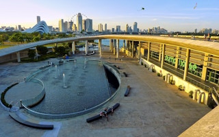
Singapore’s Marina Barrage, which was created by building a barrage across the 350m-wide Marina Channel, was featured in the C40 Climate Change Adaptation in Delta Cities guide as a solution for managing freshwater scarcity and source protection of rivers.
The guide noted that the Marina Barrage took on three functions— it helps secure Singapore’s water supply as a reservoir; forms part of a flood control system to alleviate flooding in Singapore’s low-lying areas; and is being used by residents for recreational activities and community activities.
It is an example of how cities can build its resilience to future climate change events and is particularly important if the economies of these cities rely on coastal infrastructure, such as port facilities.
“Climate change adaptation builds resilience to longer-term or future threats and risks, such as sea-level rise or temperature surges. Timely adaptation measures can help, for example, reduce future damages to or overload on urban infrastructure, avert emergencies such as freshwater shortages caused by groundwater salinisation, or prevent migration from flooded coastal zones,” said the guide.
The guide also cites Hong Kong and Copenhagen for successfully managing flooding during extreme heavy rainfall. This is especially crucial for low-lying delta cities with high water tables unable to drain or naturally manage rainfall.
Traditional methods of managing rainwater often involve expensive and extensive systems of drains, pipes and pumps, but delta cities are experimenting with other innovative solutions for slowing and absorbing rainwater to prevent damage and disruption.
Hong Kong overhauled its drainage infrastructure after conducting detailed hydraulic studies of its different drainage basins. One of the resulting innovations is the Happy Valley Underground Stormwater Storage Scheme—the first of three such schemes—comprising storage tanks with a capacity of 60,000 m3 that are being constructed beneath several sports fields.
Copenhagen decided to “fight flooding with flooding” by lowering its parks and raising the sidewalks of the streets connected to the parks. During extreme downpours, the parks will turn into temporary reservoirs while the streets become canals that channel the water towards the city’s harbour.
Singapore adopts a similar approach to Hong Kong and Copenhagen in stormwater and flood management. It currently takes a “source-pathway-receptor” approach, using green roofs, rain gardens or retention ponds to slow down the flow of stormwater discharged from buildings into the drainage system at the source. It also manages stormwater discharge through measures such as widening and deepening of drains and canals, as well as construction of flood barriers.
It is timely that Singapore is taking measures to address future sea level rise, including raising Nicoll Drive next to Changi beach by 0.8m above its present level, notes Dr Wong.
He has also observed new building platform levels at Changi airport being raised “much higher—up to half the height of a regular lamp-post”.
The guide also highlights Rotterdam’s innovative integrated land use and water systems approach to city planning.
The Dutch city’s flood-proofing measures, particularly floating buildings deployed in areas vulnerable to flooding and rising sea levels, are models that Singapore can learn from, said Dr Wong, who believes that low-lying parts of our island will be affected by sea-level rise and would benefit from alternative flood mitigation strategies, such as amphibious architecture.
He suggested that Singapore also look into amphibious architecture, which would allow structures to float on the surface of rising floodwater rather than be inundated.
Noting that Bangkok has already prototyped floating and amphibious buildings, Dr Wong said he thinks Bangkok, with help from the Dutch, will be the pioneer in Southeast Asia for amphibious buildings.
Coastal cities are some of the most advanced in terms of climate change adaptation and preparation, with good solutions to share with peer cities around the world, highlight the guide.
C40 said that it hopes cities across the world will be able to adopt and replicate the examples highlighted in the guides.
“This will allow cities to take meaningful action on climate change more quickly, at a lower cost and achieve greater impact than if they were acting alone,” said C40.
The story was first published on the NCCS website. Subscribe to their newsletter here or follow them on their Facebook page.


