A private firm in Bangladesh is planning to put up a 30 MW solar power plant on Madarer Char, an island formed by sediments brought down from the Himalayas by the Teesta river. A joint venture with a French company, the island is in the Dimla sub-district of Nilphamari district in north-western Bangladesh, about 40 km downstream from the place where the transboundary river Teesta enters Bangladesh from India.
The joint venture company formed for the purpose by Bangladeshi business house Nilsagor Group and the French company Velcan Energy will sell the electricity to the national grid.
While a sediment-formed island – called char – can suffer partial or complete inundation, some of them get so big they become permanent islands. Madarer Char, seven km long and five km wide, has existed for at least 70 years now.
Locating the solar plant on an island is one of the solutions to a persistent problem that such installations face in South Asia – lack of available land. While this island is inhabited and farmed, there are fewer people who will be displaced and will have to be compensated, Nilsagor Group officials say.
Velcan Energy will invest USD 40 million for a 51 per cent stake in the joint venture. The project proposal has been sent to the Ministry of Power, Energy and Mineral Resources and is currently being evaluated.
The power plant needs about 120 acres. “We chose the field in a permanent char (shoal) which is beyond the flood risk zone,” said Mohammed Ahsan Habib Lalin, chairman of Nilsagor Group.
“We have applied for permission for setting up the plant which is now at the final stage,” he told thethirdpole.net, adding that they will be able to supply power to the national grid within a year, if they obtain the permission by this October as projected.
The project will use a photovoltaic system in which the panels will rotate to catch the maximum amount of sunlight.
“
Any char land, even 100 years old, can go under water. But it does not happen overnight, it’s a long process. If erosion starts, the project authorities will need to rely on river training.
Ainun Nishat, hydrologist, Bangladesh
Bureaucrats say the project has not been given the go-ahead yet because the joint venture wants to sell power to the national grid at 17 cents per unit while the government wants to set a price between 13 and 14 cents. Lalin was hopeful that the pricing issue would be resolved soon.
Displacement and compensation
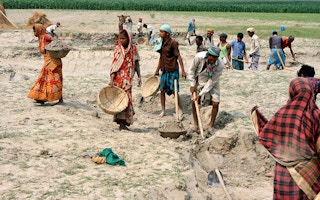
The power plant is planned on an island now inhabited by some fishermen, some farmers and their families. Asked about compensation in case they were displaced, Lalin said, “Char lands are mostly owned by some local powerful people who never rely on those lands in a big way, as there is always a possibility that these lands will go under water after a few years.”
But while they are there, these islands have very fertile soil, so their ownership has been a matter of strife in Bangladesh and eastern India for centuries. Nilsagor Group officials said they land on which they are planning to build the solar plant now belongs to three families, while the farmers are tenants. The company plans to buy the land from these families. Their officials expressed the hope the farmers would be compensated with that money.
The project developers do plan to grow vegetables and Napier grass (used as fodder) among the solar panels. They think this can add significantly to their profits, apart from being an eco-friendly move. Lalin said, “There is no chance of harming the environment; it’s impossible. This land was under water for years, now it is producing a few crops and one year later it will produce power with vegetables and Napier grass for cattle rearing.”
Flood risk
Though Lalin is confident that the solar plant will be above the highest flood zone, there is a risk, given the history of flooding in Bangladesh. In recent decades, there have been major floods in 1966, 1987, 1988, 1998 and 2016. Madarer char was affected by the 1988 flood which lasted for 20 days. According to official records, the flood inundated about 82,000 sq. km (about 60 per cent of the area).
Asked about the flood risk, eminent hydrologist Ainun Nishat said, “The return period of the catastrophic 1988 flood is estimated to be 50-100 years. So, there is always a possibility that this will be affected by floods. But the risk can be reduced by further land filling and raising the land beyond the 1988 flood level.”
Regarding the durability of a char, he said, “Any char land, even 100 years old, can go under water. But it does not happen overnight, it’s a long process. If erosion starts, the project authorities will need to rely on river training.”
Overall, he termed the site selection as “good” because such riverine islands are not optimally utilised in Bangladesh.
This story was published with permission from The Third Pole.
Read the full story.


