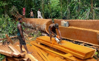
A program under which pulpwood and logging companies in Indonesia must preserve and restore any peat habitats that fall within their concessions could lead to greater deforestation, NGOs warn.
Up to half the land that could potentially be awarded to these companies under a land swap scheme is classified as natural forest, the groups say. This amounts to 9,719 square kilometers (3,753 square miles) of forest, an area roughly the size of Lebanon.
“We fear that vast areas of natural forest, especially in Kalimantan [Indonesian Borneo], Sumatra and Papua will be designated for land swaps and converted into pulpwood plantations in the name of peatland restoration,” the coalition of NGOs said in a statement.
The biggest concern among activists is Indonesia’s easternmost region of Papua, home to 35 per cent of Indonesia’s remaining rainforest and the last untouched swaths of pristine forest left in the country.
The land in sparsely populated Papua is already being targeted by the government and businesses as a new frontier ripe for logging concessions and oil palm plantations, which have already nearly depleted the forests of Sumatra and Kalimantan.
The land swap program threatens to accelerate the pace of deforestation in Papua, the NGOs say. They calculate that Papua faces the biggest risk of deforestation under the program of any region in Indonesia: Up to 4,730 square kilometers (1,825 square miles) of natural forest, an area the size of Grand Canyon National Park, could potentially be handed over to pulpwood and timber producers under the scheme.
Next in line is Kalimantan, with 2,590 square kilometers (1,000 square miles) of forest area at risk, as identified by the NGOs.
“
The area identified by the ministry is significant because almost all areas in Papua are still natural forest.
Syahrul Fitra, Auriga Nusantara
Lack of details
Under the land swap program, pulpwood and logging companies, referred to collectively as timber companies, with concessions that contain at least 40 per cent protected peatland (defined as having a layer of peat at least 3 meters deep) are required to protect and restore those areas of their concessions.
In exchange, the government will compensate them with land elsewhere.
The program is part of Indonesia’s wider efforts at restoring its carbon-rich peatlands, which have been heavily degraded by draining and burning to make way for commercial logging and agriculture.
The annual burning of peat forests poses not just an environmental disaster but a public health one too, as the resultant haze spreads and sickens tens of thousands of people.
Under a Ministry of Environment and Forestry directive issued in September 2017, the government has identified 9,212 square kilometers (3,557 square miles) of empty land throughout Indonesia for the swap.
This comprises 3,159 square kilometers (1,219 square miles) in Kalimantan, 2,744 square kilometers (1,059 square miles) in Sumatra, 1,581 square kilometers (610 square miles) in Papua, 1,012 square kilometers (390 square miles) in Maluku, 605 square kilometers (233 square miles) in Nusa Tenggara, and 111 square kilometers (42 square miles) in Sulawesi.
All these lands are located in former timber concessions that are either not being used or for which a license has been sought but has not yet been issued.
While this information is accessible to public via the ministry’s website, the process of how these particular areas were determined to be the best for the land swap was carried out without transparency or public input. Even the map attached to the ministry’s directive fails to include the locations of the swaps.
This lack of details on the locations of the swaps accounts for the discrepancy between the areas indicated in the ministry’s directive for each province and those considered at risk by the NGOs.
For instance, the directive identifies 1,581 square kilometers of land swap areas in Papua, while the NGOs found a potential eligible area three times that size, at 4,730 square kilometers.
“The area identified by the ministry is significant because almost all areas in Papua are still natural forest,” Syahrul Fitra, from the NGO Auriga Nusantara, told Mongabay. “So if it’s true that 1,581 square kilometers of lands in Papua are going to be given, where are the locations? If they come from inactive timber concessions, then these areas must have been natural forest.”
He said that, the final size notwithstanding, the fact the ministry had identified such a large area in Papua alone to be given to timber firms without any public input or transparency was enough to raise alarms.
Besides the threat of deforestation, there are also concerns over potential conflicts with local communities. The usual reason a logging concession is abandoned or not cultivated in Indonesia is because of conflicts with locals who oppose the presence of the timber operation in their midst. If the land swap program were to grant these inactive logging concessions to other companies, it might reignite those conflicts, Syahrul said.
Safeguards
The coalition of NGOs has called on the government to put safeguards in place to prevent the land swap program from triggering wholesale deforestation and social conflicts. These proposed measures include prioritizing inactive mining sites; avoiding areas that have natural forests, even if degraded; and avoiding lands that are claimed or managed by local communities.
The government should also require companies to restore the peatlands in their concessions first and have the results approved, before being granted the substitute lands. Without such provisions, the former concessions might be neglected and vulnerable to fires, Syahrul said.
“Companies have to be responsible for the areas that they leave behind,” he said.
He also called on the government to allocate new lands based on the actual area managed by companies, not on the size of their concessions. Failing to do so will advantage the companies, Syahrul said.
The NGOs are also pushing for greater transparency in the whole process, starting with publishing the names of companies involved in the peat restoration program and land swap program.
“It’s been almost a year since the ministerial regulations [on the peat restoration and land swap programs] were issued, so there must have been lots of progress,” Syahrul said. “But to date the process has never been opened to the public and there’s no transparency from the ministry itself. I don’t know why.”
Auriga Nusantara wrote to the environment ministry last month, seeking information on the land swap areas. The ministry, however, refused the request, saying the program was still “in process” and the information could not yet be shared.
A PowerPoint presentation made by the ministry in December 2017 and seen by Mongabay shows the ministry has already identified 99 companies whose concessions include peat areas. The total peat overlap area amounts to 25,923 square kilometers (10,008 square miles) in 11 provinces, of which 14,311 square kilometers (5,525 square miles) are designated as protected peatlands.
The PowerPoint also shows the environment ministry has identified at least 18 companies that will get substitute lands under the program.
But the document is not publicly available, and civil society groups have been left to rely on information that may already be outdated to monitor the land swap program.
“What we need is the exact locations of the swaps,” Syahrul said. “If there’s a map, then it’s better so that people can verify the locations on the ground. If not, then we’re just playing a guessing game. We also need the names of the companies so that we can check whether the sizes of the substitute lands match their managed concessions or not.”
Hilman Nugroho, the environment ministry’s newly appointed director-general of planology, said the map for the land swap program was not ready yet because the ministry had to ensure that the substitute lands did not overlap with natural forests and lands managed by local communities.
“We’ll overlay the [land swap] map with other maps, so that we only give lands that are truly safe and free from conflicts with locals,” he said during a recent event in Jakarta.
Once the full picture is ready, the ministry will make it accessible to the public, Hilman said.
“We’ll prepare the map,” he said. “The public will be able to see [the map].”
This story was published with permission from Mongabay.com


