For the first time, researchers have begun to collect accurate data on the thickness of the sea ice around Antarctica.
A new underwater robot called SeaBED has begun to deliver a clear picture of the greatest mass of floating frozen water on the planet. And the first evidence is that the ice is thicker than anyone had realised: on average somewhere between 1.4 and 5.5 metres, but sometimes as much as 16 metres or more.
Although scientists can keep an eye on the precise extent of the seasonal ice, thanks to consistent satellite data, looking beneath the rim of floating ice that surrounds the enormous continent has been more of a problem. But it’s a problem SeaBED is now addressing by producing the first detailed, high-resolution 3-D maps of Antarctic sea ice.
Baseline measurement
Ice thickness measurements are not easy. During the Cold War, nuclear submarines routinely cruised under the Arctic Ocean ice, making measurements – for navigational safety reasons, rather than climate research. But, in consequence, when the Arctic ice sheet started to melt and dwindle, researchers had a baseline of accurate measurement.
“
We strongly depend on the simulation of the sea ice in these models to test possible causes of the Antarctic sea ice expansion
David Ferreira, an oceanographer at the University of Reading
The Antarctic, however, is a partly-submerged rocky continent that bears a huge burden of snow and ice. Shipboard and shore-based studies can provide only a limited set of measurements of ice thickness off its coasts.
Now Guy Williams, a polar oceanographer at the University of Tasmania Institute for Marine and Antarctic Studies, and colleagues from the British Antarctic Survey and other institutions, report in Nature Geoscience that at last they have a clearer picture of the ice thickness, and therefore a better chance of calculating how sea ice is likely to change as the planet’s climate continues to warm.
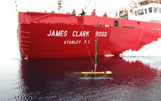
SeaBED, technically described as an autonomous underwater vehicle (AUV), is a little yellow submarine two metres long and weighing 200 kg. It was designed and built by the Woods Hole Oceanographic Institution in the US.
In 2010 and 2012 it made a series of autonomous underwater traverses in lawnmower fashion, at depths of 20-30 metres. Most surveying instruments look down, but this one looks up at the ice above it.
There has been a level of alarm at change in Antarctica in recent years. Although the sea ice during recent polar winters has been greater than ever there has been concern about the rate at which some Antarctic glaciers are melting − with worrying consequences for the rate of sea level rise.
Accurate estimates
So the more accurate the information about the volumes of ice formed and lost, the more accurate the estimates of future sea level rise, and the better the understanding of the polar climate machinery.
The AUV measurements – especially when backed up by direct measurements, radar and satellite studies – promise to provide a real insight into the nature of Antarctic sea ice.
Jeremy Wilkinson, lead investigator at the British Antarctic Survey, says: “We can now measure in far greater detail, and were excited to measure ice up to 17 metres thick.”
David Ferreira, an oceanographer at the University of Reading, who is not one of the authors, called the study “a formidable benchmark” in formulating climate models of the region.
“We strongly depend on the simulation of the sea ice in these models to test possible causes of the Antarctic sea ice expansion,” he said. “Effects of the ozone hole, of melt water from the Antarctic ice sheet, or of sea ice movements are among the plausible candidates, but we are limited by the quality of our models in this poorly-observed region of the world to discriminate between them.”


