A map using satellite technology to warn of fire risks aims at helping Southeast Asian governments better deploy their resources to combat raging blazes, which cloak the region in haze every year, an expert on forest fires said on Tuesday.
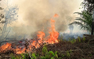
Slash-and-burn agriculture, much of it clearing land for palm oil crops, blanketed Singapore, Malaysia and northern Indonesia in a choking “haze” for months last year.
Updated daily, the Fire Risk Map calculates the risk of a fire catching and spreading using the latest satellite data on temperature, humidity and rainfall in the region. Drier conditions signal higher risks of blazes starting and spreading.
“We expect the Fire Risk Map to help government officials and company land managers to be more proactive about fires,” Susan Minnemeyer, a forest fire expert at Global Forest Watch, told the Thomson Reuters Foundation.
The Washington-based non-profit developed the tool with environmental group Conservation International.
The groups said although most of Indonesia’s fires are started by locals to clear land, the levels of land dryness can indicate how flammable the fires are and whether they will blaze out of control.
“
We expect the Fire Risk Map to help government officials and company land managers to be more proactive about fires.
Susan Minnemeyer, forest fire expert, Global Forest Watch
The tool will gives officials, companies and local communities a chance to take action before fires start, for example by retaining water for firefighting and deploying resources to places where fires are likely to spread.
Last year’s forest fires, primarily in Indonesia, were among the worst on record, forcing flights to be cancelled, schools to shut and thousands to fall ill across the region.
Minnemeyer said although Indonesia is entering its high-risk dry season, when fires typically spike, the dry season is predicted to be shorter this year due to a high chance of the La Nina weather pattern occurring.
Weather forecasters in Japan, Australia and the United States predict a 50 per cent to 75 per cent chance of La Nina - when waters in the eastern Pacific Ocean cool - developing in the second half of 2016.
Indonesia experiences its dry season from June to October, but last year’s fires were worse due to El Nino, a warming of sea-surface temperatures in the Pacific, which caused tinder-dry conditions and helped keep forests burning until mid-November.
“However, because the El Nino has ended, the dry season should be shorter and less severe than in 2015,” Minnemeyer said.
“La Nina conditions, which means wetter-than-average conditions in Indonesia are expected as early as September,” she added.
This story is published with permission from Thomson Reuters Foundation, the charitable arm of Thomson Reuters, that covers humanitarian news, women’s rights, trafficking, property rights and climate change. Visit http://news.trust.org


