Google has unveiled a map showing air quality in Singapore and Malaysia in near real-time for the first time, as the region begins to breathe easier after weeks of haze from fires in Indonesia.
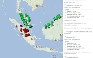
The map (http://google.org/crisismap/2013-se-asia-fires) which relies on air-quality data from government monitoring stations in Singapore and Malaysia, showed pollution levels in both countries within safe ranges today after hitting record hazardous levels last month. Information on air quality in Indonesia was not included because it was not readily available, Google said.
According to the Wall Street Journal, the map also makes use of data from a fire-tracking satellite of the National Oceanic and Atmospheric Administration in the United States to map out hotspots as well as a NASA imaging satellite to show an overlay of the haze that still hangs over the region.
The map is Google’s first foray into the annual fires emanating from agricultural lands in Indonesia, although its crisis division has worked on similar ad-hoc projects in the past, including during the Japan tsunami and for wildfires in Australia.
Other organizations, such as the Washington-based World Resources Institute and Indonesian environmental groups, have released online maps showing hotspots data overlaid with partial maps of concession boundaries in Riau province on Sumatra island, where the majority of the fires are occurring this year. Fires in Riau are often started to cheaply clear land for use in the multibillion-dollar palm oil and pulpwood industries.
Riau experienced around 8,000 fires last month, about four times the usual amount, amid drier skies and indications of increasing land conversion on peatlands, where fires are more difficult to extinguish. Rain in the past week has subdued many of the blazes across the province, but experts warn that more are likely as the region enters the heart of the dry season in the coming weeks.
Google says it plans to keep its map up for the duration of the fires and haze.


