Why are scientists turning to aerial images to monitor the health of ecosystems found beneath the ocean’s surface?
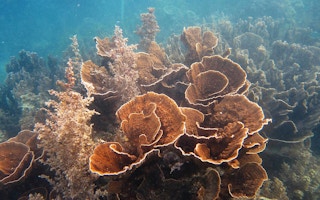
Coral reefs support millions of species ranging from single-celled algae to sharks and sea turtles. However, this diversity, coupled with the scattered and often remote (underwater) locations of reefs, makes it challenging to monitor these ecosystems effectively.
To survey reefs, experts must spend time in the water, identifying and counting species. This approach requires substantial time and resources and may also lead to biased results that are difficult to compare over time.
Recently, scientists have begun surveying reefs using images captured from satellites. Analyzing images allows researchers to more accurately compare surveys from different time periods and to cover a larger area with each survey.
However, the usefulness of these satellite images is limited by their low resolution. Researchers in Australia are now conducting surveys using unmanned aerial vehicles (UAVs) and hyperspectral cameras to gather more detailed images and data on the health of coral reefs.
What is hyperspectral imaging?
Receptors in the human eye detect a narrow range of wavelengths in the electromagnetic spectrum–the area we call visible light, consisting of three bands of energy that our eyes perceive as red, green and blue. The combination of these bands that an object reflects determines the colors we see. Similarly, a standard camera captures an image recorded in these three bands of visible light.
Materials can be differentiated based on the unique signature of wavelengths their surface reflects. Like a human fingerprint, this spectral signature makes it possible to identify a material once its signature is known. Images taken with a hyperspectral camera record this spectral signature using more and narrower wavelength bands that generally cover a wider range of the electromagnetic spectrum than the three bands of visual images.
In an email to Mongabay-Wildtech, Dr. Felipe Gonzalez, Associate Professor at the Queensland University of Technology (QUT), described the advantages of this technology. “Whilst regular cameras acquire image samples at only three fixed wavelength bands (visible red, green and blue), hyperspectral cameras scan the same scenery at a much [greater] amount and range of spectral bands. QUT’s hyperspectral camera, for instance, acquires samples of up to 270 wavelength bands ranging from the visible spectrum to NIR [near-infrared].”
Hyperspectral imaging was originally developed for mining and geology purposes, but researchers are beginning to take advantage of the detailed images for coral reef surveys and other environmental monitoring applications.
“
Using the hyperspectral data acquired from these images, we are able to find patterns that distinguish levels of coral bleaching, water pollution, amongst others.
Dr. Felipe Gonzalez, associate professor, Queensland University of Technology
Assessing the reef from the skies
The specialized hyperspectral camera was originally a huge, expensive device. Gonzalez and his colleagues at QUT have developed a miniaturized hyperspectral camera that can be carried by an unmanned aerial vehicle (UAV).
Their camera produces hyperspectral images with a high enough spatial resolution (15 cm/pixel) to identify and monitor individual corals. In comparison, the Hyperspectral Imager for the Coastal Ocean (HICO), a camera which was installed on the International Space Station in 2015, captured images of coral reefs at a 90 m/pixel resolution.
Using this set-up, the researchers have obtained aerial hyperspectral images of the Ningaloo Reef – part of the Ningaloo Coast World Heritage Site of Western Australia. Ningaloo is one of the world’s largest fringing reefs, spanning nearly 300 km, and is well-known for the population of whale sharks that gather there annually to feed.
Compared to other large reefs, such as the Great Barrier in eastern Australia, Ningaloo has been very resistant to bleaching and disease. The 2017 IUCN World Heritage Outlook gave the Ningaloo reef its most positive rating for ‘Conservation Outlook’. Consequently, having the technology to closely monitor the reef will help to quickly detect any changes in its health and possibly provide insight into its resilience.
Satellites have already obtained aerial images of the reef; however, the UAV makes it possible to capture images from a significantly closer distance (30-100 m from the water’s surface), resulting in high enough spatial resolution to survey the benthic composition of a reef (coral, sand, algae, etc.) and monitor the health of individual corals.
Flying the UAV at a 100 m altitude, Gonzalez and his team can photograph 40 ha of Ningaloo Reef in about 30 minutes. Using the hyperspectral data acquired from these images, Gonzalez says they are able to “find patterns that distinguish levels of coral bleaching, water pollution, amongst others.”
However, according to Gonzalez, the “huge amount of data represents some challenges regarding data filtering, interpretability and computational effort.” Gonzalez and his colleagues are developing artificial intelligence software that will learn how to automatically recognize the unique spectral “fingerprints” that the camera detects. This software will be able to differentiate coral species and predict the level of bleaching in individual corals. It also will be able to identify other features of the reef, such as sand and algae.
Assessing the reef from below the surface
Coral reef researchers are also beginning to take the technology underwater. Dr. Arjun Chennu, a research scientist at the Max Planck Institute for Marine Microbiology, recently helped to develop the HyperDiver – a diver-operated apparatus that not only captures hyperspectral images, but also measures water chemistry (pH and O2) and records the seafloor topography. The hyperspectral imagery enables the diver team to map benthic habitats, coral pigment densities and coral structure (rugosity) at the fine scale of a reef.
The Reefscape project is using aerial and underwater hyperspectral cameras to construct a spectral library that, when coupled with satellite imaging, will potentially make it possible to survey the coverage and health of coral reefs on a global scale. Spectral patterns reflect the unique chemical signature of an object. The signature of unhealthy corals or trees differs from that of healthy ones, so changes in this signature could indicate a decline in health or structure of coral.
The challenges of high cost and complex data analysis have limited the adoption of hyperspectral imaging for environmental research and conservation. However, with the popularity of the technology increasing, lower-cost hyperspectral cameras are being developed. Moreover, as artificial intelligence software for identifying spectral signatures improves, the analysis of hyperspectral data has the potential to become largely automated.
The economic value of coral reefs has been estimated at nearly $30 billion annually, with tourism contributing over $9 billion. Reefs support fisheries and protect shorelines by buffering against waves and storm surges. However, increasing ocean temperatures and acidity have led to more frequent occurrences of coral bleaching. Local-scale pollution and sedimentation further damage reef ecosystems.
This story was published with permission from Mongabay.com. Read the full story.


